You are here: Home > Network List > TA - USArray Transportable Network (new EarthScope stations) Stations List
> Station J04D Umpqua National Forest, Toketee, OR, USA > Earthquake Result Viewer
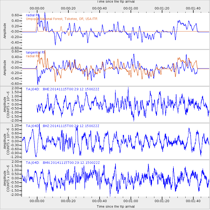
J04D Umpqua National Forest, Toketee, OR, USA - Earthquake Result Viewer
*The percent match for this event was below the threshold and hence no stack was calculated.
| Earthquake location: |
Near Coast Of Peru |
| Earthquake latitude/longitude: |
-12.7/-76.7 |
| Earthquake time(UTC): |
2014/11/15 (319) 00:18:40 GMT |
| Earthquake Depth: |
46 km |
| Earthquake Magnitude: |
5.6 MB |
| Earthquake Catalog/Contributor: |
NEIC PDE/NEIC COMCAT |
|
| Network: |
TA USArray Transportable Network (new EarthScope stations) |
| Station: |
J04D Umpqua National Forest, Toketee, OR, USA |
| Lat/Lon: |
43.24 N/122.11 W |
| Elevation: |
1948 m |
|
| Distance: |
69.4 deg |
| Az: |
326.244 deg |
| Baz: |
132.086 deg |
| Ray Param: |
$rayparam |
*The percent match for this event was below the threshold and hence was not used in the summary stack. |
|
| Radial Match: |
49.04159 % |
| Radial Bump: |
400 |
| Transverse Match: |
54.947884 % |
| Transverse Bump: |
400 |
| SOD ConfigId: |
817349 |
| Insert Time: |
2014-11-29 00:40:51.555 +0000 |
| GWidth: |
2.5 |
| Max Bumps: |
400 |
| Tol: |
0.001 |
|
Signal To Noise
| Channel | StoN | STA | LTA |
| TA:J04D: :BHZ:20141115T00:29:12.150022Z | 1.8236277 | 6.739788E-7 | 3.6958133E-7 |
| TA:J04D: :BHN:20141115T00:29:12.150022Z | 1.5582316 | 6.3050965E-7 | 4.0463152E-7 |
| TA:J04D: :BHE:20141115T00:29:12.150022Z | 1.2892604 | 7.799149E-7 | 6.0493204E-7 |
| Arrivals |
| Ps | |
| PpPs | |
| PsPs/PpSs | |


