You are here: Home > Network List > TA - USArray Transportable Network (new EarthScope stations) Stations List
> Station P59A Jarrettsville, MD, USA > Earthquake Result Viewer
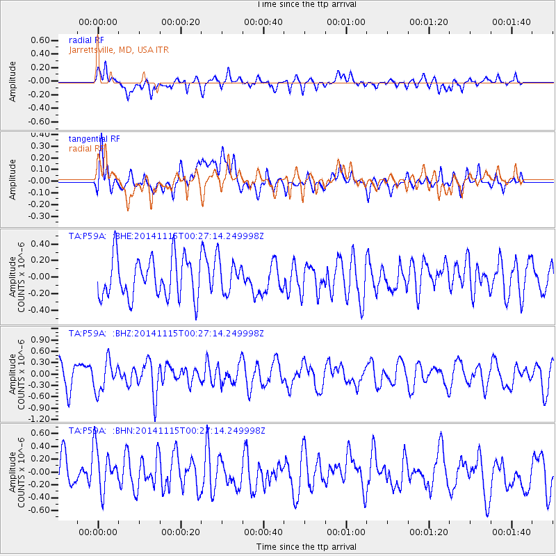
P59A Jarrettsville, MD, USA - Earthquake Result Viewer
*The percent match for this event was below the threshold and hence no stack was calculated.
| Earthquake location: |
Near Coast Of Peru |
| Earthquake latitude/longitude: |
-12.7/-76.7 |
| Earthquake time(UTC): |
2014/11/15 (319) 00:18:40 GMT |
| Earthquake Depth: |
46 km |
| Earthquake Magnitude: |
5.6 MB |
| Earthquake Catalog/Contributor: |
NEIC PDE/NEIC COMCAT |
|
| Network: |
TA USArray Transportable Network (new EarthScope stations) |
| Station: |
P59A Jarrettsville, MD, USA |
| Lat/Lon: |
39.61 N/76.43 W |
| Elevation: |
157 m |
|
| Distance: |
52.0 deg |
| Az: |
0.309 deg |
| Baz: |
180.39 deg |
| Ray Param: |
$rayparam |
*The percent match for this event was below the threshold and hence was not used in the summary stack. |
|
| Radial Match: |
58.87059 % |
| Radial Bump: |
400 |
| Transverse Match: |
63.523438 % |
| Transverse Bump: |
400 |
| SOD ConfigId: |
817349 |
| Insert Time: |
2014-11-29 00:42:04.593 +0000 |
| GWidth: |
2.5 |
| Max Bumps: |
400 |
| Tol: |
0.001 |
|
Signal To Noise
| Channel | StoN | STA | LTA |
| TA:P59A: :BHZ:20141115T00:27:14.249998Z | 1.2634468 | 4.0609373E-7 | 3.2141733E-7 |
| TA:P59A: :BHN:20141115T00:27:14.249998Z | 1.6209219 | 3.5306164E-7 | 2.1781534E-7 |
| TA:P59A: :BHE:20141115T00:27:14.249998Z | 0.77866757 | 1.8832019E-7 | 2.4184928E-7 |
| Arrivals |
| Ps | |
| PpPs | |
| PsPs/PpSs | |


