You are here: Home > Network List > YB13 - Continental Dynamics/Cent. Anatolian Tectonics:Surface to Mantle Dynamics During Stations List
> Station AT38 Bayraktepe?,Gaziantep,Turkey > Earthquake Result Viewer
AT38 Bayraktepe?,Gaziantep,Turkey - Earthquake Result Viewer
| Earthquake location: |
Southeast Of Honshu, Japan |
| Earthquake latitude/longitude: |
31.2/142.4 |
| Earthquake time(UTC): |
2015/05/10 (130) 21:25:46 GMT |
| Earthquake Depth: |
18 km |
| Earthquake Magnitude: |
5.6 MB |
| Earthquake Catalog/Contributor: |
NEIC PDE/NEIC COMCAT |
|
| Network: |
YB Continental Dynamics/Cent. Anatolian Tectonics:Surface to Mantle Dynamics During |
| Station: |
AT38 Bayraktepe?,Gaziantep,Turkey |
| Lat/Lon: |
37.04 N/36.81 E |
| Elevation: |
692 m |
|
| Distance: |
82.8 deg |
| Az: |
309.013 deg |
| Baz: |
56.269 deg |
| Ray Param: |
0.04663453 |
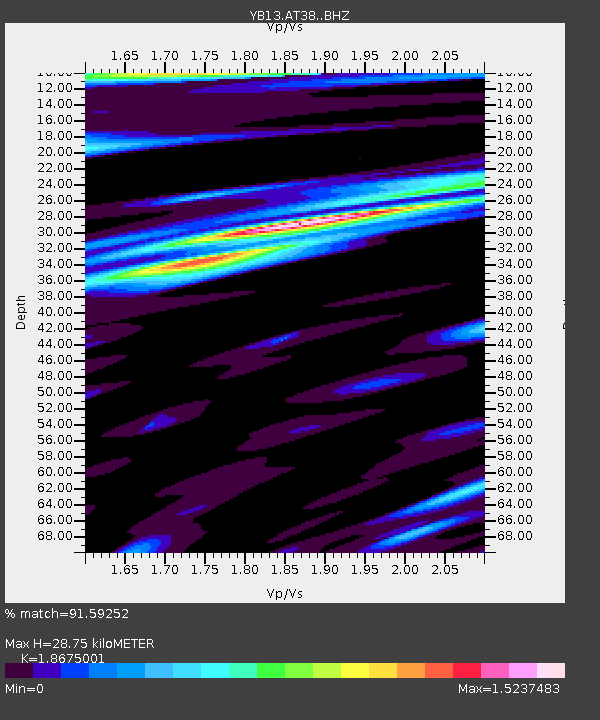
| Estimated Moho Depth: |
28.75 km |
| Estimated Crust Vp/Vs: |
1.87 |
| Assumed Crust Vp: |
6.247 km/s |
| Estimated Crust Vs: |
3.345 km/s |
| Estimated Crust Poisson's Ratio: |
0.30 |
|
| Radial Match: |
91.59252 % |
| Radial Bump: |
400 |
| Transverse Match: |
88.08393 % |
| Transverse Bump: |
400 |
| SOD ConfigId: |
7422571 |
| Insert Time: |
2019-04-18 19:22:39.898 +0000 |
| GWidth: |
2.5 |
| Max Bumps: |
400 |
| Tol: |
0.001 |
|

Signal To Noise
| Channel | StoN | STA | LTA |
| YB:AT38: :BHZ:20150510T21:37:38.638999Z | 6.382829 | 5.595764E-7 | 8.766902E-8 |
| YB:AT38: :BHN:20150510T21:37:38.638999Z | 1.9711998 | 1.7399275E-7 | 8.826744E-8 |
| YB:AT38: :BHE:20150510T21:37:38.638999Z | 2.7339694 | 1.8353651E-7 | 6.7131886E-8 |
| Arrivals |
| Ps | 4.1 SECOND |
| PpPs | 13 SECOND |
| PsPs/PpSs | 17 SECOND |


