You are here: Home > Network List > AK - Alaska Regional Network Stations List
> Station MDM Murphy Dome > Earthquake Result Viewer
MDM Murphy Dome - Earthquake Result Viewer
| Earthquake location: |
Northern Molucca Sea |
| Earthquake latitude/longitude: |
1.9/126.5 |
| Earthquake time(UTC): |
2014/11/15 (319) 02:31:40 GMT |
| Earthquake Depth: |
35 km |
| Earthquake Magnitude: |
7.1 MWW, 7.0 MWW, 7.3 MI |
| Earthquake Catalog/Contributor: |
NEIC PDE/NEIC COMCAT |
|
| Network: |
AK Alaska Regional Network |
| Station: |
MDM Murphy Dome |
| Lat/Lon: |
64.96 N/148.23 W |
| Elevation: |
634 m |
|
| Distance: |
86.2 deg |
| Az: |
25.154 deg |
| Baz: |
266.491 deg |
| Ray Param: |
0.04415016 |
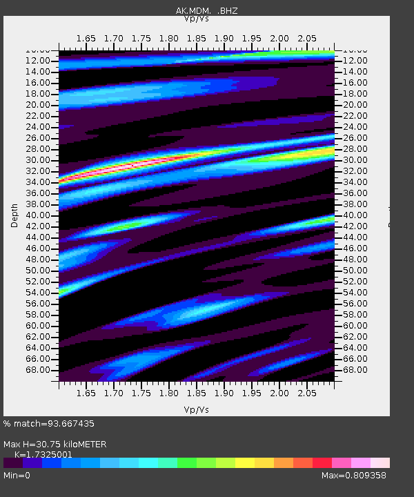
| Estimated Moho Depth: |
30.75 km |
| Estimated Crust Vp/Vs: |
1.73 |
| Assumed Crust Vp: |
6.566 km/s |
| Estimated Crust Vs: |
3.79 km/s |
| Estimated Crust Poisson's Ratio: |
0.25 |
|
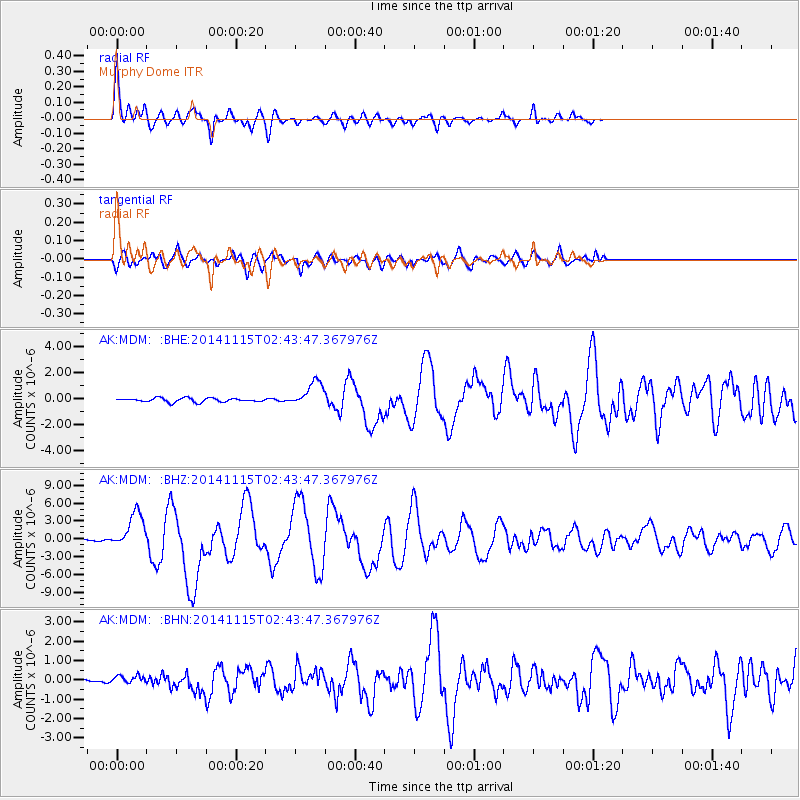
| Radial Match: |
93.667435 % |
| Radial Bump: |
400 |
| Transverse Match: |
82.35605 % |
| Transverse Bump: |
400 |
| SOD ConfigId: |
817472 |
| Insert Time: |
2014-11-29 02:42:30.295 +0000 |
| GWidth: |
2.5 |
| Max Bumps: |
400 |
| Tol: |
0.001 |
|
Signal To Noise
| Channel | StoN | STA | LTA |
| AK:MDM: :BHZ:20141115T02:43:47.367976Z | 11.679979 | 3.0531792E-6 | 2.614028E-7 |
| AK:MDM: :BHN:20141115T02:43:47.367976Z | 0.92252785 | 2.163053E-7 | 2.344702E-7 |
| AK:MDM: :BHE:20141115T02:43:47.367976Z | 6.3853784 | 9.59315E-7 | 1.502362E-7 |
| Arrivals |
| Ps | 3.5 SECOND |
| PpPs | 12 SECOND |
| PsPs/PpSs | 16 SECOND |


