You are here: Home > Network List > AK - Alaska Regional Network Stations List
> Station SSP Sunshine Point, AK, USA > Earthquake Result Viewer
SSP Sunshine Point, AK, USA - Earthquake Result Viewer
| Earthquake location: |
Northern Molucca Sea |
| Earthquake latitude/longitude: |
1.9/126.5 |
| Earthquake time(UTC): |
2014/11/15 (319) 02:31:40 GMT |
| Earthquake Depth: |
35 km |
| Earthquake Magnitude: |
7.1 MWW, 7.0 MWW, 7.3 MI |
| Earthquake Catalog/Contributor: |
NEIC PDE/NEIC COMCAT |
|
| Network: |
AK Alaska Regional Network |
| Station: |
SSP Sunshine Point, AK, USA |
| Lat/Lon: |
60.18 N/142.84 W |
| Elevation: |
474 m |
|
| Distance: |
88.6 deg |
| Az: |
29.995 deg |
| Baz: |
271.489 deg |
| Ray Param: |
0.042384077 |
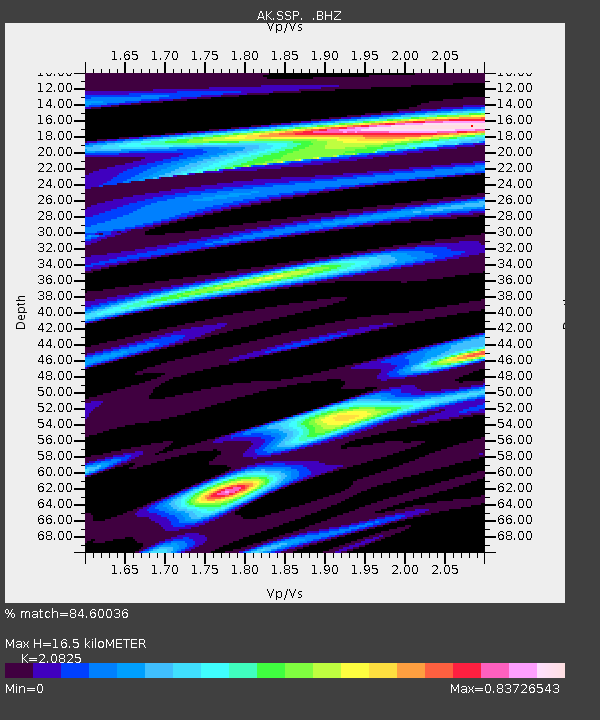
| Estimated Moho Depth: |
16.5 km |
| Estimated Crust Vp/Vs: |
2.08 |
| Assumed Crust Vp: |
6.566 km/s |
| Estimated Crust Vs: |
3.153 km/s |
| Estimated Crust Poisson's Ratio: |
0.35 |
|
| Radial Match: |
84.60036 % |
| Radial Bump: |
400 |
| Transverse Match: |
88.9627 % |
| Transverse Bump: |
400 |
| SOD ConfigId: |
817472 |
| Insert Time: |
2014-11-29 02:43:37.095 +0000 |
| GWidth: |
2.5 |
| Max Bumps: |
400 |
| Tol: |
0.001 |
|

Signal To Noise
| Channel | StoN | STA | LTA |
| AK:SSP: :BHZ:20141115T02:43:58.947993Z | 4.7662835 | 3.4497562E-6 | 7.237833E-7 |
| AK:SSP: :BHN:20141115T02:43:58.947993Z | 2.0262542 | 1.2163636E-6 | 6.003016E-7 |
| AK:SSP: :BHE:20141115T02:43:58.947993Z | 2.5957723 | 1.0843769E-6 | 4.1774734E-7 |
| Arrivals |
| Ps | 2.8 SECOND |
| PpPs | 7.6 SECOND |
| PsPs/PpSs | 10 SECOND |


