You are here: Home > Network List > AK - Alaska Regional Network Stations List
> Station TGL Tana Glacier > Earthquake Result Viewer
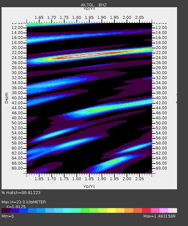
TGL Tana Glacier - Earthquake Result Viewer
| Earthquake location: |
Northern Molucca Sea |
| Earthquake latitude/longitude: |
1.9/126.5 |
| Earthquake time(UTC): |
2014/11/15 (319) 02:31:40 GMT |
| Earthquake Depth: |
35 km |
| Earthquake Magnitude: |
7.1 MWW, 7.0 MWW, 7.3 MI |
| Earthquake Catalog/Contributor: |
NEIC PDE/NEIC COMCAT |
|
| Network: |
AK Alaska Regional Network |
| Station: |
TGL Tana Glacier |
| Lat/Lon: |
60.75 N/142.83 W |
| Elevation: |
1260 m |
|
| Distance: |
88.6 deg |
| Az: |
29.417 deg |
| Baz: |
271.485 deg |
| Ray Param: |
0.04239102 |
| Estimated Moho Depth: |
23.0 km |
| Estimated Crust Vp/Vs: |
1.81 |
| Assumed Crust Vp: |
6.566 km/s |
| Estimated Crust Vs: |
3.623 km/s |
| Estimated Crust Poisson's Ratio: |
0.28 |
|
| Radial Match: |
88.61223 % |
| Radial Bump: |
400 |
| Transverse Match: |
92.0691 % |
| Transverse Bump: |
400 |
| SOD ConfigId: |
817472 |
| Insert Time: |
2014-11-29 02:43:47.078 +0000 |
| GWidth: |
2.5 |
| Max Bumps: |
400 |
| Tol: |
0.001 |
|

Signal To Noise
| Channel | StoN | STA | LTA |
| AK:TGL: :BHZ:20141115T02:43:58.908015Z | 15.411238 | 2.747457E-6 | 1.7827621E-7 |
| AK:TGL: :BHN:20141115T02:43:58.908015Z | 1.7308695 | 4.6587704E-7 | 2.691578E-7 |
| AK:TGL: :BHE:20141115T02:43:58.908015Z | 5.307446 | 7.945639E-7 | 1.4970739E-7 |
| Arrivals |
| Ps | 2.9 SECOND |
| PpPs | 9.6 SECOND |
| PsPs/PpSs | 13 SECOND |


