You are here: Home > Network List > AV - Alaska Volcano Observatory Stations List
> Station AKSA Akutan Strait, Akutan Volcano, Alaska > Earthquake Result Viewer
AKSA Akutan Strait, Akutan Volcano, Alaska - Earthquake Result Viewer
| Earthquake location: |
Northern Molucca Sea |
| Earthquake latitude/longitude: |
1.9/126.5 |
| Earthquake time(UTC): |
2014/11/15 (319) 02:31:40 GMT |
| Earthquake Depth: |
35 km |
| Earthquake Magnitude: |
7.1 MWW, 7.0 MWW, 7.3 MI |
| Earthquake Catalog/Contributor: |
NEIC PDE/NEIC COMCAT |
|
| Network: |
AV Alaska Volcano Observatory |
| Station: |
AKSA Akutan Strait, Akutan Volcano, Alaska |
| Lat/Lon: |
54.11 N/165.70 W |
| Elevation: |
213 m |
|
| Distance: |
75.5 deg |
| Az: |
34.252 deg |
| Baz: |
252.812 deg |
| Ray Param: |
0.051552556 |
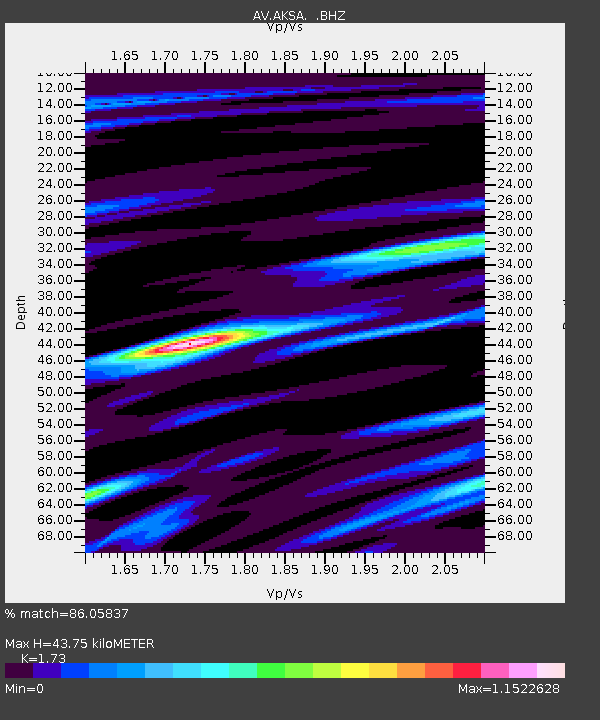
| Estimated Moho Depth: |
43.75 km |
| Estimated Crust Vp/Vs: |
1.73 |
| Assumed Crust Vp: |
5.989 km/s |
| Estimated Crust Vs: |
3.462 km/s |
| Estimated Crust Poisson's Ratio: |
0.25 |
|
| Radial Match: |
86.05837 % |
| Radial Bump: |
400 |
| Transverse Match: |
81.80407 % |
| Transverse Bump: |
400 |
| SOD ConfigId: |
817472 |
| Insert Time: |
2014-11-29 02:45:58.871 +0000 |
| GWidth: |
2.5 |
| Max Bumps: |
400 |
| Tol: |
0.001 |
|
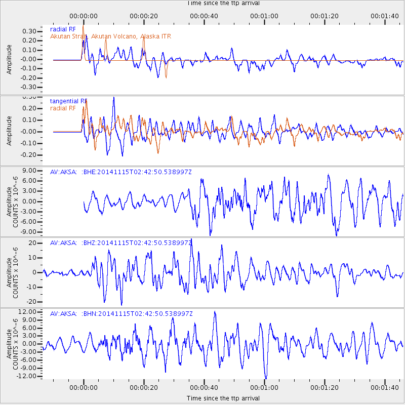
Signal To Noise
| Channel | StoN | STA | LTA |
| AV:AKSA: :BHZ:20141115T02:42:50.538997Z | 3.4989483 | 4.2285674E-6 | 1.2085252E-6 |
| AV:AKSA: :BHN:20141115T02:42:50.538997Z | 1.7979294 | 2.2911884E-6 | 1.2743483E-6 |
| AV:AKSA: :BHE:20141115T02:42:50.538997Z | 1.4008836 | 2.102379E-6 | 1.5007521E-6 |
| Arrivals |
| Ps | 5.5 SECOND |
| PpPs | 19 SECOND |
| PsPs/PpSs | 25 SECOND |


