You are here: Home > Network List > IU - Global Seismograph Network (GSN - IRIS/USGS) Stations List
> Station JOHN Johnston Island, USA > Earthquake Result Viewer
JOHN Johnston Island, USA - Earthquake Result Viewer
| Earthquake location: |
Northern Molucca Sea |
| Earthquake latitude/longitude: |
1.9/126.5 |
| Earthquake time(UTC): |
2014/11/15 (319) 02:31:40 GMT |
| Earthquake Depth: |
35 km |
| Earthquake Magnitude: |
7.1 MWW, 7.0 MWW, 7.3 MI |
| Earthquake Catalog/Contributor: |
NEIC PDE/NEIC COMCAT |
|
| Network: |
IU Global Seismograph Network (GSN - IRIS/USGS) |
| Station: |
JOHN Johnston Island, USA |
| Lat/Lon: |
16.73 N/169.53 W |
| Elevation: |
2.0 m |
|
| Distance: |
64.5 deg |
| Az: |
72.467 deg |
| Baz: |
264.042 deg |
| Ray Param: |
0.058825538 |
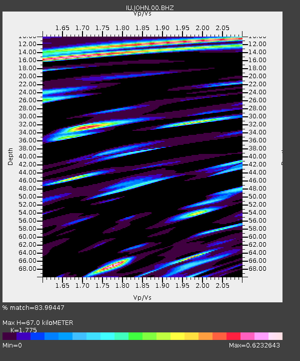
| Estimated Moho Depth: |
67.0 km |
| Estimated Crust Vp/Vs: |
1.77 |
| Assumed Crust Vp: |
4.24 km/s |
| Estimated Crust Vs: |
2.389 km/s |
| Estimated Crust Poisson's Ratio: |
0.27 |
|
| Radial Match: |
83.99447 % |
| Radial Bump: |
344 |
| Transverse Match: |
50.19787 % |
| Transverse Bump: |
304 |
| SOD ConfigId: |
817472 |
| Insert Time: |
2014-11-29 02:50:28.565 +0000 |
| GWidth: |
2.5 |
| Max Bumps: |
400 |
| Tol: |
0.001 |
|

Signal To Noise
| Channel | StoN | STA | LTA |
| IU:JOHN:00:BHZ:20141115T02:41:43.044001Z | 3.0910652 | 5.280894E-6 | 1.7084384E-6 |
| IU:JOHN:00:BH1:20141115T02:41:43.044001Z | 1.0487872 | 3.044027E-6 | 2.9024256E-6 |
| IU:JOHN:00:BH2:20141115T02:41:43.044001Z | 1.1764351 | 2.9276187E-6 | 2.488551E-6 |
| Arrivals |
| Ps | 12 SECOND |
| PpPs | 43 SECOND |
| PsPs/PpSs | 56 SECOND |


