You are here: Home > Network List > S - Seismographs in Schools Projects Stations List
> Station AUMTS Mt Stromlo, ANU > Earthquake Result Viewer
AUMTS Mt Stromlo, ANU - Earthquake Result Viewer
| Earthquake location: |
Northern Molucca Sea |
| Earthquake latitude/longitude: |
1.9/126.5 |
| Earthquake time(UTC): |
2014/11/15 (319) 02:31:40 GMT |
| Earthquake Depth: |
35 km |
| Earthquake Magnitude: |
7.1 MWW, 7.0 MWW, 7.3 MI |
| Earthquake Catalog/Contributor: |
NEIC PDE/NEIC COMCAT |
|
| Network: |
S Seismographs in Schools Projects |
| Station: |
AUMTS Mt Stromlo, ANU |
| Lat/Lon: |
35.32 S/149.00 E |
| Elevation: |
667 m |
|
| Distance: |
42.6 deg |
| Az: |
152.524 deg |
| Baz: |
325.675 deg |
| Ray Param: |
0.07301297 |
| Estimated Moho Depth: |
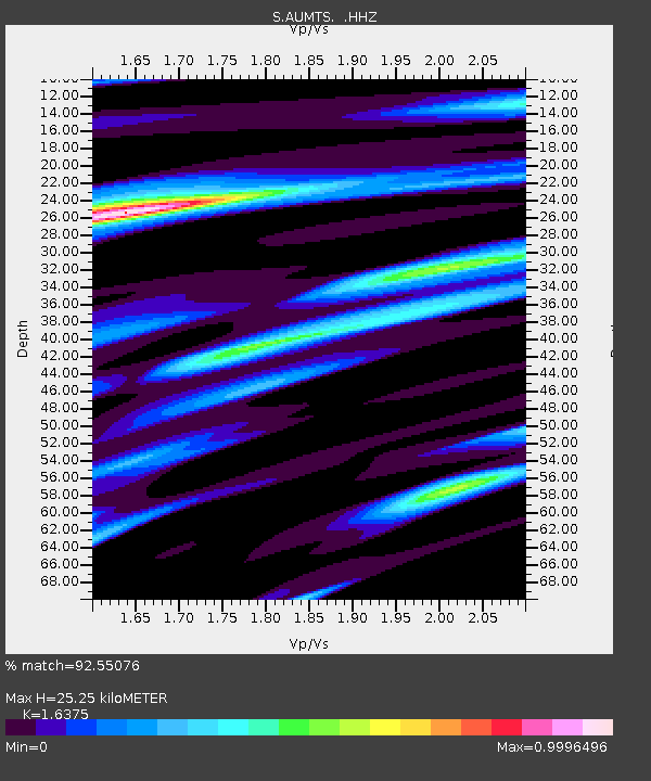
25.25 km |
| Estimated Crust Vp/Vs: |
1.64 |
| Assumed Crust Vp: |
6.633 km/s |
| Estimated Crust Vs: |
4.051 km/s |
| Estimated Crust Poisson's Ratio: |
0.20 |
|
| Radial Match: |
92.55076 % |
| Radial Bump: |
375 |
| Transverse Match: |
84.88527 % |
| Transverse Bump: |
400 |
| SOD ConfigId: |
817472 |
| Insert Time: |
2014-11-29 02:54:22.179 +0000 |
| GWidth: |
2.5 |
| Max Bumps: |
400 |
| Tol: |
0.001 |
|

Signal To Noise
| Channel | StoN | STA | LTA |
| S:AUMTS: :HHZ:20141115T02:39:02.860011Z | 9.638733 | 1.0330965E-5 | 1.0718178E-6 |
| S:AUMTS: :HHN:20141115T02:39:02.860011Z | 6.264426 | 6.520853E-6 | 1.0409337E-6 |
| S:AUMTS: :HHE:20141115T02:39:02.860011Z | 2.9249842 | 3.3389585E-6 | 1.1415304E-6 |
| Arrivals |
| Ps | 2.6 SECOND |
| PpPs | 9.3 SECOND |
| PsPs/PpSs | 12 SECOND |


