You are here: Home > Network List > TJ - Tajikistan National Seismic Network Stations List
> Station CHGR Chuyangaron, Tajikistan > Earthquake Result Viewer
CHGR Chuyangaron, Tajikistan - Earthquake Result Viewer
| Earthquake location: |
Northern Molucca Sea |
| Earthquake latitude/longitude: |
1.9/126.5 |
| Earthquake time(UTC): |
2014/11/15 (319) 02:31:40 GMT |
| Earthquake Depth: |
35 km |
| Earthquake Magnitude: |
7.1 MWW, 7.0 MWW, 7.3 MI |
| Earthquake Catalog/Contributor: |
NEIC PDE/NEIC COMCAT |
|
| Network: |
TJ Tajikistan National Seismic Network |
| Station: |
CHGR Chuyangaron, Tajikistan |
| Lat/Lon: |
38.66 N/69.16 E |
| Elevation: |
1049 m |
|
| Distance: |
63.7 deg |
| Az: |
312.656 deg |
| Baz: |
110.15 deg |
| Ray Param: |
0.05932375 |
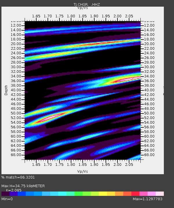
| Estimated Moho Depth: |
34.75 km |
| Estimated Crust Vp/Vs: |
2.07 |
| Assumed Crust Vp: |
6.483 km/s |
| Estimated Crust Vs: |
3.139 km/s |
| Estimated Crust Poisson's Ratio: |
0.35 |
|
| Radial Match: |
86.3201 % |
| Radial Bump: |
400 |
| Transverse Match: |
77.99609 % |
| Transverse Bump: |
400 |
| SOD ConfigId: |
817472 |
| Insert Time: |
2014-11-29 02:55:26.268 +0000 |
| GWidth: |
2.5 |
| Max Bumps: |
400 |
| Tol: |
0.001 |
|

Signal To Noise
| Channel | StoN | STA | LTA |
| TJ:CHGR: :HHZ:20141115T02:41:38.039973Z | 49.866806 | 6.34703E-6 | 1.2727966E-7 |
| TJ:CHGR: :HHN:20141115T02:41:38.039973Z | 5.2119594 | 1.2350795E-6 | 2.3697028E-7 |
| TJ:CHGR: :HHE:20141115T02:41:38.039973Z | 20.007608 | 2.3964765E-6 | 1.1977826E-7 |
| Arrivals |
| Ps | 5.9 SECOND |
| PpPs | 16 SECOND |
| PsPs/PpSs | 22 SECOND |


