You are here: Home > Network List > G - GEOSCOPE Stations List
> Station NOUC Port Laguerre, New Caledonia > Earthquake Result Viewer
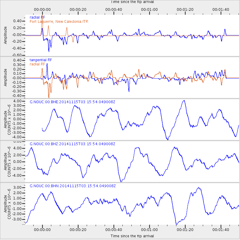
NOUC Port Laguerre, New Caledonia - Earthquake Result Viewer
*The percent match for this event was below the threshold and hence no stack was calculated.
| Earthquake location: |
Minahassa Peninsula, Sulawesi |
| Earthquake latitude/longitude: |
-0.1/123.9 |
| Earthquake time(UTC): |
2014/11/15 (319) 03:08:04 GMT |
| Earthquake Depth: |
85 km |
| Earthquake Magnitude: |
5.8 MB |
| Earthquake Catalog/Contributor: |
NEIC PDE/NEIC COMCAT |
|
| Network: |
G GEOSCOPE |
| Station: |
NOUC Port Laguerre, New Caledonia |
| Lat/Lon: |
22.10 S/166.30 E |
| Elevation: |
112 m |
|
| Distance: |
46.7 deg |
| Az: |
120.778 deg |
| Baz: |
292.117 deg |
| Ray Param: |
$rayparam |
*The percent match for this event was below the threshold and hence was not used in the summary stack. |
|
| Radial Match: |
52.834602 % |
| Radial Bump: |
400 |
| Transverse Match: |
50.877983 % |
| Transverse Bump: |
400 |
| SOD ConfigId: |
817472 |
| Insert Time: |
2014-11-29 03:19:00.435 +0000 |
| GWidth: |
2.5 |
| Max Bumps: |
400 |
| Tol: |
0.001 |
|
Signal To Noise
| Channel | StoN | STA | LTA |
| G:NOUC:00:BHZ:20141115T03:15:54.049008Z | 1.9556798 | 3.0479923E-6 | 1.5585333E-6 |
| G:NOUC:00:BHN:20141115T03:15:54.049008Z | 0.8841551 | 2.0243028E-6 | 2.2895338E-6 |
| G:NOUC:00:BHE:20141115T03:15:54.049008Z | 0.5599368 | 1.0234921E-6 | 1.8278707E-6 |
| Arrivals |
| Ps | |
| PpPs | |
| PsPs/PpSs | |


