You are here: Home > Network List > CN - Canadian National Seismograph Network Stations List
> Station INK INUVIK, NT > Earthquake Result Viewer
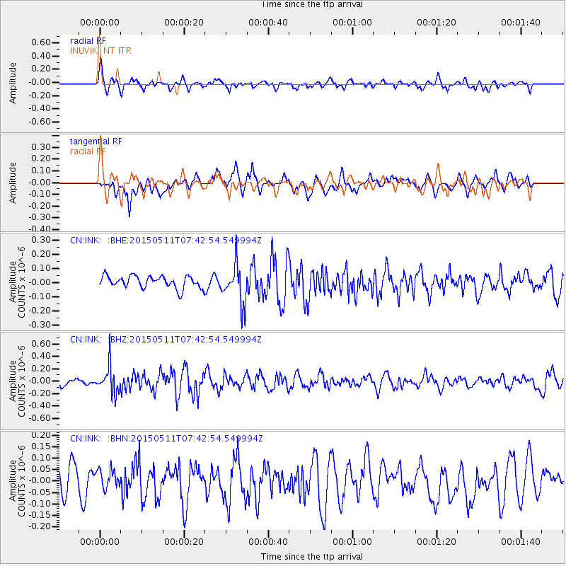
INK INUVIK, NT - Earthquake Result Viewer
*The percent match for this event was below the threshold and hence no stack was calculated.
| Earthquake location: |
Kuril Islands |
| Earthquake latitude/longitude: |
47.2/154.1 |
| Earthquake time(UTC): |
2015/05/11 (131) 07:35:44 GMT |
| Earthquake Depth: |
22 km |
| Earthquake Magnitude: |
5.2 MW, 4.7 MS, 5.3 mb |
| Earthquake Catalog/Contributor: |
ISC/ISC |
|
| Network: |
CN Canadian National Seismograph Network |
| Station: |
INK INUVIK, NT |
| Lat/Lon: |
68.31 N/133.53 W |
| Elevation: |
44 m |
|
| Distance: |
40.9 deg |
| Az: |
32.752 deg |
| Baz: |
277.066 deg |
| Ray Param: |
$rayparam |
*The percent match for this event was below the threshold and hence was not used in the summary stack. |
|
| Radial Match: |
58.544453 % |
| Radial Bump: |
400 |
| Transverse Match: |
55.638683 % |
| Transverse Bump: |
400 |
| SOD ConfigId: |
7422571 |
| Insert Time: |
2019-04-18 19:34:35.638 +0000 |
| GWidth: |
2.5 |
| Max Bumps: |
400 |
| Tol: |
0.001 |
|
Signal To Noise
| Channel | StoN | STA | LTA |
| CN:INK: :BHZ:20150511T07:42:54.549994Z | 3.0145857 | 2.1804523E-7 | 7.233008E-8 |
| CN:INK: :BHN:20150511T07:42:54.549994Z | 0.8279562 | 4.3152742E-8 | 5.2119596E-8 |
| CN:INK: :BHE:20150511T07:42:54.549994Z | 3.3968875 | 1.4429588E-7 | 4.2478852E-8 |
| Arrivals |
| Ps | |
| PpPs | |
| PsPs/PpSs | |


