You are here: Home > Network List > AU - Australian Seismological Centre Stations List
> Station MEEK Meekatharra, Western Australia > Earthquake Result Viewer
MEEK Meekatharra, Western Australia - Earthquake Result Viewer
| Earthquake location: |
Off E. Coast Of N. Island, N.Z. |
| Earthquake latitude/longitude: |
-37.7/179.7 |
| Earthquake time(UTC): |
2014/11/16 (320) 22:33:20 GMT |
| Earthquake Depth: |
22 km |
| Earthquake Magnitude: |
6.7 MWW, 6.7 MWC, 6.7 MI |
| Earthquake Catalog/Contributor: |
NEIC PDE/NEIC COMCAT |
|
| Network: |
AU Australian Seismological Centre |
| Station: |
MEEK Meekatharra, Western Australia |
| Lat/Lon: |
26.64 S/118.61 E |
| Elevation: |
529 m |
|
| Distance: |
52.1 deg |
| Az: |
263.427 deg |
| Baz: |
118.287 deg |
| Ray Param: |
0.06697757 |
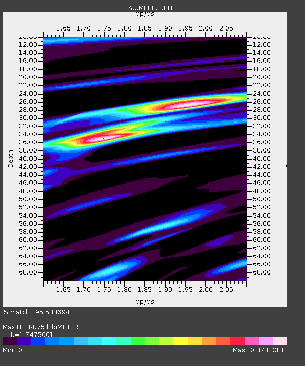
| Estimated Moho Depth: |
34.75 km |
| Estimated Crust Vp/Vs: |
1.75 |
| Assumed Crust Vp: |
6.459 km/s |
| Estimated Crust Vs: |
3.696 km/s |
| Estimated Crust Poisson's Ratio: |
0.26 |
|
| Radial Match: |
95.583694 % |
| Radial Bump: |
321 |
| Transverse Match: |
77.956055 % |
| Transverse Bump: |
400 |
| SOD ConfigId: |
818021 |
| Insert Time: |
2014-11-30 22:37:52.893 +0000 |
| GWidth: |
2.5 |
| Max Bumps: |
400 |
| Tol: |
0.001 |
|

Signal To Noise
| Channel | StoN | STA | LTA |
| AU:MEEK: :BHZ:20141116T22:41:57.893975Z | 5.5303473 | 1.3452574E-6 | 2.4325007E-7 |
| AU:MEEK: :BHN:20141116T22:41:57.893975Z | 2.333773 | 3.5111438E-7 | 1.5044925E-7 |
| AU:MEEK: :BHE:20141116T22:41:57.893975Z | 4.7508864 | 6.076355E-7 | 1.278994E-7 |
| Arrivals |
| Ps | 4.3 SECOND |
| PpPs | 14 SECOND |
| PsPs/PpSs | 18 SECOND |


