You are here: Home > Network List > AU - Australian Seismological Centre Stations List
> Station PSAA1 Pilbara Seismic Array Element A1 > Earthquake Result Viewer
PSAA1 Pilbara Seismic Array Element A1 - Earthquake Result Viewer
| Earthquake location: |
Off E. Coast Of N. Island, N.Z. |
| Earthquake latitude/longitude: |
-37.7/179.7 |
| Earthquake time(UTC): |
2014/11/16 (320) 22:33:20 GMT |
| Earthquake Depth: |
22 km |
| Earthquake Magnitude: |
6.7 MWW, 6.7 MWC, 6.7 MI |
| Earthquake Catalog/Contributor: |
NEIC PDE/NEIC COMCAT |
|
| Network: |
AU Australian Seismological Centre |
| Station: |
PSAA1 Pilbara Seismic Array Element A1 |
| Lat/Lon: |
21.58 S/119.84 E |
| Elevation: |
325 m |
|
| Distance: |
53.6 deg |
| Az: |
269.608 deg |
| Baz: |
121.527 deg |
| Ray Param: |
0.06596303 |
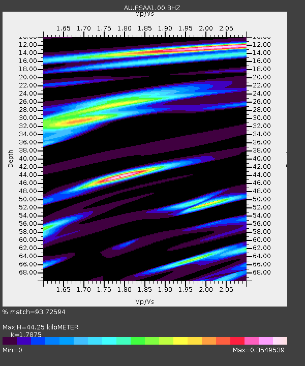
| Estimated Moho Depth: |
44.25 km |
| Estimated Crust Vp/Vs: |
1.79 |
| Assumed Crust Vp: |
6.464 km/s |
| Estimated Crust Vs: |
3.616 km/s |
| Estimated Crust Poisson's Ratio: |
0.27 |
|
| Radial Match: |
93.72594 % |
| Radial Bump: |
363 |
| Transverse Match: |
78.4967 % |
| Transverse Bump: |
400 |
| SOD ConfigId: |
818021 |
| Insert Time: |
2014-11-30 22:38:05.937 +0000 |
| GWidth: |
2.5 |
| Max Bumps: |
400 |
| Tol: |
0.001 |
|

Signal To Noise
| Channel | StoN | STA | LTA |
| AU:PSAA1:00:BHZ:20141116T22:42:09.268975Z | 2.9574568 | 8.720026E-7 | 2.948488E-7 |
| AU:PSAA1:00:BH1:20141116T22:42:09.268975Z | 2.1675649 | 2.9544026E-7 | 1.3630053E-7 |
| AU:PSAA1:00:BH2:20141116T22:42:09.268975Z | 3.952678 | 4.907155E-7 | 1.241476E-7 |
| Arrivals |
| Ps | 5.7 SECOND |
| PpPs | 18 SECOND |
| PsPs/PpSs | 24 SECOND |


