You are here: Home > Network List > AU - Australian Seismological Centre Stations List
> Station PSAA3 Pilbara Seismic Array Element A3 > Earthquake Result Viewer
PSAA3 Pilbara Seismic Array Element A3 - Earthquake Result Viewer
| Earthquake location: |
Off E. Coast Of N. Island, N.Z. |
| Earthquake latitude/longitude: |
-37.7/179.7 |
| Earthquake time(UTC): |
2014/11/16 (320) 22:33:20 GMT |
| Earthquake Depth: |
22 km |
| Earthquake Magnitude: |
6.7 MWW, 6.7 MWC, 6.7 MI |
| Earthquake Catalog/Contributor: |
NEIC PDE/NEIC COMCAT |
|
| Network: |
AU Australian Seismological Centre |
| Station: |
PSAA3 Pilbara Seismic Array Element A3 |
| Lat/Lon: |
21.58 S/119.85 E |
| Elevation: |
315 m |
|
| Distance: |
53.6 deg |
| Az: |
269.618 deg |
| Baz: |
121.526 deg |
| Ray Param: |
0.06597343 |
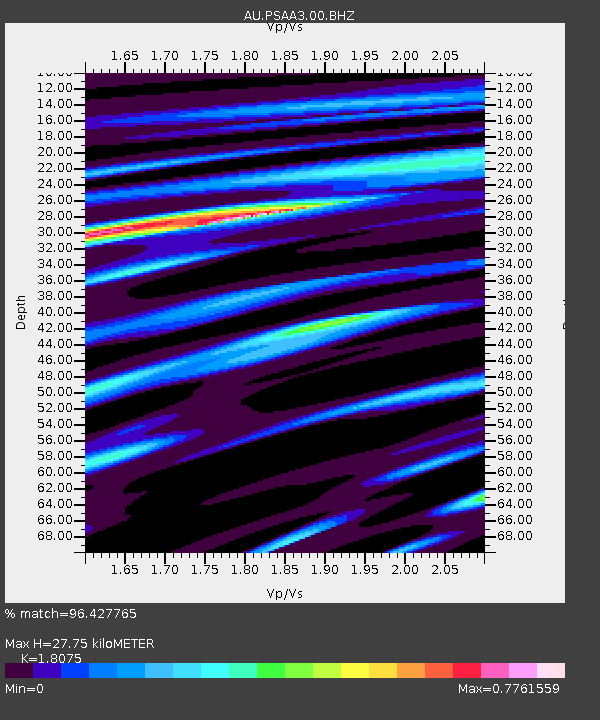
| Estimated Moho Depth: |
27.75 km |
| Estimated Crust Vp/Vs: |
1.81 |
| Assumed Crust Vp: |
6.464 km/s |
| Estimated Crust Vs: |
3.576 km/s |
| Estimated Crust Poisson's Ratio: |
0.28 |
|
| Radial Match: |
96.427765 % |
| Radial Bump: |
400 |
| Transverse Match: |
77.92292 % |
| Transverse Bump: |
400 |
| SOD ConfigId: |
818021 |
| Insert Time: |
2014-11-30 22:38:11.403 +0000 |
| GWidth: |
2.5 |
| Max Bumps: |
400 |
| Tol: |
0.001 |
|

Signal To Noise
| Channel | StoN | STA | LTA |
| AU:PSAA3:00:BHZ:20141116T22:42:09.168999Z | 5.9228034 | 9.2765805E-7 | 1.5662482E-7 |
| AU:PSAA3:00:BH1:20141116T22:42:09.168999Z | 1.6756259 | 2.7507735E-7 | 1.6416394E-7 |
| AU:PSAA3:00:BH2:20141116T22:42:09.168999Z | 3.3180175 | 4.7410037E-7 | 1.4288665E-7 |
| Arrivals |
| Ps | 3.7 SECOND |
| PpPs | 11 SECOND |
| PsPs/PpSs | 15 SECOND |


