You are here: Home > Network List > AU - Australian Seismological Centre Stations List
> Station PSAD1 Pilbara Seismic Array Element D1 > Earthquake Result Viewer
PSAD1 Pilbara Seismic Array Element D1 - Earthquake Result Viewer
| Earthquake location: |
Off E. Coast Of N. Island, N.Z. |
| Earthquake latitude/longitude: |
-37.7/179.7 |
| Earthquake time(UTC): |
2014/11/16 (320) 22:33:20 GMT |
| Earthquake Depth: |
22 km |
| Earthquake Magnitude: |
6.7 MWW, 6.7 MWC, 6.7 MI |
| Earthquake Catalog/Contributor: |
NEIC PDE/NEIC COMCAT |
|
| Network: |
AU Australian Seismological Centre |
| Station: |
PSAD1 Pilbara Seismic Array Element D1 |
| Lat/Lon: |
21.46 S/119.83 E |
| Elevation: |
280 m |
|
| Distance: |
53.7 deg |
| Az: |
269.733 deg |
| Baz: |
121.603 deg |
| Ray Param: |
0.065917335 |
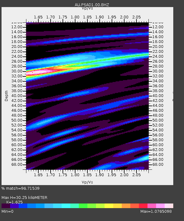
| Estimated Moho Depth: |
30.25 km |
| Estimated Crust Vp/Vs: |
1.62 |
| Assumed Crust Vp: |
6.464 km/s |
| Estimated Crust Vs: |
3.978 km/s |
| Estimated Crust Poisson's Ratio: |
0.20 |
|
| Radial Match: |
96.71539 % |
| Radial Bump: |
400 |
| Transverse Match: |
76.55977 % |
| Transverse Bump: |
400 |
| SOD ConfigId: |
818021 |
| Insert Time: |
2014-11-30 22:38:28.751 +0000 |
| GWidth: |
2.5 |
| Max Bumps: |
400 |
| Tol: |
0.001 |
|

Signal To Noise
| Channel | StoN | STA | LTA |
| AU:PSAD1:00:BHZ:20141116T22:42:09.768975Z | 5.863624 | 1.0175091E-6 | 1.7352905E-7 |
| AU:PSAD1:00:BH1:20141116T22:42:09.768975Z | 4.29218 | 5.1762305E-7 | 1.2059677E-7 |
| AU:PSAD1:00:BH2:20141116T22:42:09.768975Z | 1.4107707 | 2.1760314E-7 | 1.5424418E-7 |
| Arrivals |
| Ps | 3.1 SECOND |
| PpPs | 12 SECOND |
| PsPs/PpSs | 15 SECOND |


