You are here: Home > Network List > AU - Australian Seismological Centre Stations List
> Station PSAD2 Pilbara Seismic Array Element D2 > Earthquake Result Viewer
PSAD2 Pilbara Seismic Array Element D2 - Earthquake Result Viewer
| Earthquake location: |
Off E. Coast Of N. Island, N.Z. |
| Earthquake latitude/longitude: |
-37.7/179.7 |
| Earthquake time(UTC): |
2014/11/16 (320) 22:33:20 GMT |
| Earthquake Depth: |
22 km |
| Earthquake Magnitude: |
6.7 MWW, 6.7 MWC, 6.7 MI |
| Earthquake Catalog/Contributor: |
NEIC PDE/NEIC COMCAT |
|
| Network: |
AU Australian Seismological Centre |
| Station: |
PSAD2 Pilbara Seismic Array Element D2 |
| Lat/Lon: |
21.62 S/119.96 E |
| Elevation: |
366 m |
|
| Distance: |
53.5 deg |
| Az: |
269.642 deg |
| Baz: |
121.501 deg |
| Ray Param: |
0.06604422 |
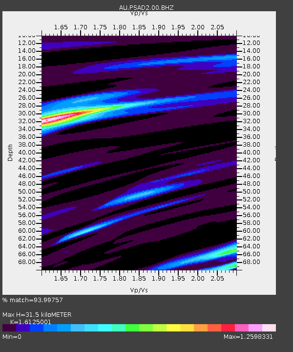
| Estimated Moho Depth: |
31.5 km |
| Estimated Crust Vp/Vs: |
1.61 |
| Assumed Crust Vp: |
6.464 km/s |
| Estimated Crust Vs: |
4.008 km/s |
| Estimated Crust Poisson's Ratio: |
0.19 |
|
| Radial Match: |
93.99757 % |
| Radial Bump: |
339 |
| Transverse Match: |
87.532104 % |
| Transverse Bump: |
400 |
| SOD ConfigId: |
818021 |
| Insert Time: |
2014-11-30 22:38:28.942 +0000 |
| GWidth: |
2.5 |
| Max Bumps: |
400 |
| Tol: |
0.001 |
|

Signal To Noise
| Channel | StoN | STA | LTA |
| AU:PSAD2:00:BHZ:20141116T22:42:08.393975Z | 4.1972213 | 1.1401539E-6 | 2.7164495E-7 |
| AU:PSAD2:00:BH1:20141116T22:42:08.393975Z | 2.0319102 | 4.6315304E-7 | 2.2793974E-7 |
| AU:PSAD2:00:BH2:20141116T22:42:08.393975Z | 1.8118576 | 4.0619193E-7 | 2.2418536E-7 |
| Arrivals |
| Ps | 3.2 SECOND |
| PpPs | 12 SECOND |
| PsPs/PpSs | 15 SECOND |


