You are here: Home > Network List > AZ - ANZA Regional Network Stations List
> Station SMER AZ.SMER > Earthquake Result Viewer
SMER AZ.SMER - Earthquake Result Viewer
*The percent match for this event was below the threshold and hence no stack was calculated.
| Earthquake location: |
Off E. Coast Of N. Island, N.Z. |
| Earthquake latitude/longitude: |
-37.7/179.7 |
| Earthquake time(UTC): |
2014/11/16 (320) 22:33:20 GMT |
| Earthquake Depth: |
22 km |
| Earthquake Magnitude: |
6.7 MWW, 6.7 MWC, 6.7 MI |
| Earthquake Catalog/Contributor: |
NEIC PDE/NEIC COMCAT |
|
| Network: |
AZ ANZA Regional Network |
| Station: |
SMER AZ.SMER |
| Lat/Lon: |
33.46 N/117.17 W |
| Elevation: |
355 m |
|
| Distance: |
92.0 deg |
| Az: |
48.268 deg |
| Baz: |
225.092 deg |
| Ray Param: |
$rayparam |
*The percent match for this event was below the threshold and hence was not used in the summary stack. |
|
| Radial Match: |
71.73456 % |
| Radial Bump: |
400 |
| Transverse Match: |
54.403038 % |
| Transverse Bump: |
400 |
| SOD ConfigId: |
818021 |
| Insert Time: |
2014-11-30 22:39:42.637 +0000 |
| GWidth: |
2.5 |
| Max Bumps: |
400 |
| Tol: |
0.001 |
|
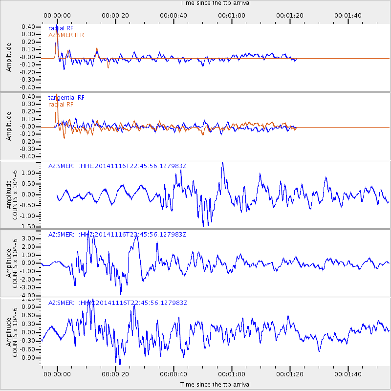
Signal To Noise
| Channel | StoN | STA | LTA |
| AZ:SMER: :HHZ:20141116T22:45:56.127983Z | 3.0469286 | 4.1710064E-7 | 1.3689217E-7 |
| AZ:SMER: :HHN:20141116T22:45:56.127983Z | 0.726063 | 2.0173368E-7 | 2.7784597E-7 |
| AZ:SMER: :HHE:20141116T22:45:56.127983Z | 1.1583962 | 2.3731604E-7 | 2.0486604E-7 |
| Arrivals |
| Ps | |
| PpPs | |
| PsPs/PpSs | |


