You are here: Home > Network List > GE - GEOFON Stations List
> Station SNAA GEOFON/AWI Station Sanae, Antarctica > Earthquake Result Viewer
SNAA GEOFON/AWI Station Sanae, Antarctica - Earthquake Result Viewer
| Earthquake location: |
Off E. Coast Of N. Island, N.Z. |
| Earthquake latitude/longitude: |
-37.7/179.7 |
| Earthquake time(UTC): |
2014/11/16 (320) 22:33:20 GMT |
| Earthquake Depth: |
22 km |
| Earthquake Magnitude: |
6.7 MWW, 6.7 MWC, 6.7 MI |
| Earthquake Catalog/Contributor: |
NEIC PDE/NEIC COMCAT |
|
| Network: |
GE GEOFON |
| Station: |
SNAA GEOFON/AWI Station Sanae, Antarctica |
| Lat/Lon: |
71.67 S/2.84 W |
| Elevation: |
846 m |
|
| Distance: |
70.9 deg |
| Az: |
179.156 deg |
| Baz: |
182.118 deg |
| Ray Param: |
0.054629672 |
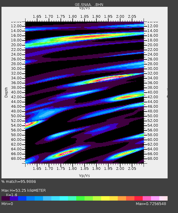
| Estimated Moho Depth: |
53.25 km |
| Estimated Crust Vp/Vs: |
1.60 |
| Assumed Crust Vp: |
6.43 km/s |
| Estimated Crust Vs: |
4.019 km/s |
| Estimated Crust Poisson's Ratio: |
0.18 |
|
| Radial Match: |
95.9886 % |
| Radial Bump: |
400 |
| Transverse Match: |
77.32701 % |
| Transverse Bump: |
400 |
| SOD ConfigId: |
818021 |
| Insert Time: |
2014-11-30 22:43:50.714 +0000 |
| GWidth: |
2.5 |
| Max Bumps: |
400 |
| Tol: |
0.001 |
|
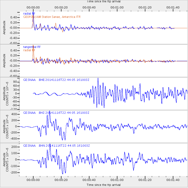
Signal To Noise
| Channel | StoN | STA | LTA |
| GE:SNAA: :BHZ:20141116T22:44:05.161003Z | 7.392229 | 4.7192443E-5 | 6.384061E-6 |
| GE:SNAA: :BHN:20141116T22:44:05.161003Z | 4.557218 | 1.7762213E-5 | 3.8976E-6 |
| GE:SNAA: :BHE:20141116T22:44:05.161003Z | 0.74849683 | 5.0800645E-6 | 6.787022E-6 |
| Arrivals |
| Ps | 5.2 SECOND |
| PpPs | 21 SECOND |
| PsPs/PpSs | 26 SECOND |


