You are here: Home > Network List > TA - USArray Transportable Network (new EarthScope stations) Stations List
> Station I04A Tendick Farm, Oakridge, OR, USA > Earthquake Result Viewer
I04A Tendick Farm, Oakridge, OR, USA - Earthquake Result Viewer
| Earthquake location: |
Off E. Coast Of N. Island, N.Z. |
| Earthquake latitude/longitude: |
-37.7/179.7 |
| Earthquake time(UTC): |
2014/11/16 (320) 22:33:20 GMT |
| Earthquake Depth: |
22 km |
| Earthquake Magnitude: |
6.7 MWW, 6.7 MWC, 6.7 MI |
| Earthquake Catalog/Contributor: |
NEIC PDE/NEIC COMCAT |
|
| Network: |
TA USArray Transportable Network (new EarthScope stations) |
| Station: |
I04A Tendick Farm, Oakridge, OR, USA |
| Lat/Lon: |
43.79 N/122.41 W |
| Elevation: |
731 m |
|
| Distance: |
96.6 deg |
| Az: |
38.136 deg |
| Baz: |
222.577 deg |
| Ray Param: |
0.040466286 |
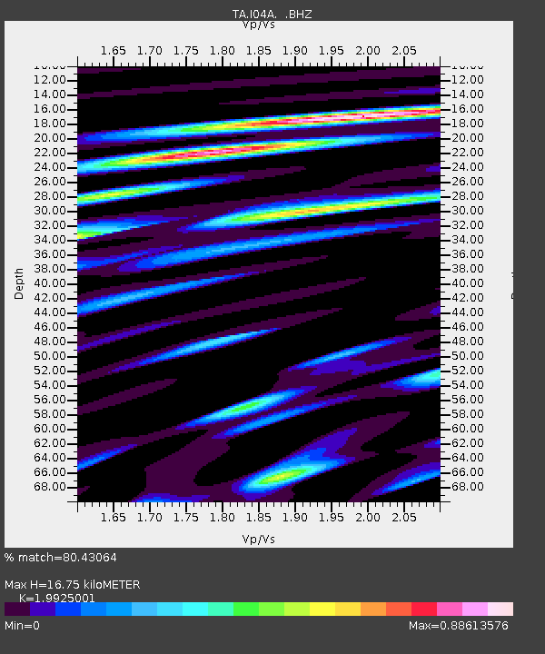
| Estimated Moho Depth: |
16.75 km |
| Estimated Crust Vp/Vs: |
1.99 |
| Assumed Crust Vp: |
6.522 km/s |
| Estimated Crust Vs: |
3.273 km/s |
| Estimated Crust Poisson's Ratio: |
0.33 |
|
| Radial Match: |
80.43064 % |
| Radial Bump: |
400 |
| Transverse Match: |
52.94306 % |
| Transverse Bump: |
400 |
| SOD ConfigId: |
818021 |
| Insert Time: |
2014-11-30 22:49:52.160 +0000 |
| GWidth: |
2.5 |
| Max Bumps: |
400 |
| Tol: |
0.001 |
|

Signal To Noise
| Channel | StoN | STA | LTA |
| TA:I04A: :BHZ:20141116T22:46:17.100029Z | 2.693602 | 5.028977E-7 | 1.8670082E-7 |
| TA:I04A: :BHN:20141116T22:46:17.100029Z | 0.6312197 | 9.368213E-8 | 1.4841446E-7 |
| TA:I04A: :BHE:20141116T22:46:17.100029Z | 0.85628206 | 1.501454E-7 | 1.7534572E-7 |
| Arrivals |
| Ps | 2.6 SECOND |
| PpPs | 7.5 SECOND |
| PsPs/PpSs | 10 SECOND |


