You are here: Home > Network List > C1 - Red Sismologica Nacional Stations List
> Station CO03 El Pedregal > Earthquake Result Viewer
CO03 El Pedregal - Earthquake Result Viewer
| Earthquake location: |
Off E. Coast Of N. Island, N.Z. |
| Earthquake latitude/longitude: |
-37.7/179.7 |
| Earthquake time(UTC): |
2014/11/16 (320) 22:33:20 GMT |
| Earthquake Depth: |
22 km |
| Earthquake Magnitude: |
6.7 MWW, 6.7 MWC, 6.7 MI |
| Earthquake Catalog/Contributor: |
NEIC PDE/NEIC COMCAT |
|
| Network: |
C1 Red Sismologica Nacional |
| Station: |
CO03 El Pedregal |
| Lat/Lon: |
30.84 S/70.69 W |
| Elevation: |
1003 m |
|
| Distance: |
85.3 deg |
| Az: |
125.625 deg |
| Baz: |
228.572 deg |
| Ray Param: |
0.044815 |
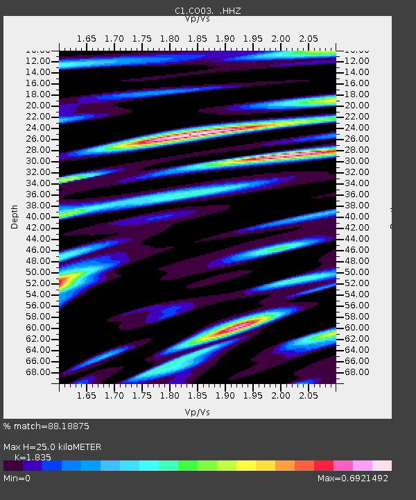
| Estimated Moho Depth: |
25.0 km |
| Estimated Crust Vp/Vs: |
1.84 |
| Assumed Crust Vp: |
6.481 km/s |
| Estimated Crust Vs: |
3.532 km/s |
| Estimated Crust Poisson's Ratio: |
0.29 |
|
| Radial Match: |
88.18875 % |
| Radial Bump: |
400 |
| Transverse Match: |
79.00202 % |
| Transverse Bump: |
400 |
| SOD ConfigId: |
818021 |
| Insert Time: |
2014-11-30 22:52:58.371 +0000 |
| GWidth: |
2.5 |
| Max Bumps: |
400 |
| Tol: |
0.001 |
|

Signal To Noise
| Channel | StoN | STA | LTA |
| C1:CO03: :HHZ:20141116T22:45:24.669976Z | 1.6697752 | 6.2159694E-7 | 3.7226386E-7 |
| C1:CO03: :HHN:20141116T22:45:24.669976Z | 0.8157582 | 1.9178039E-7 | 2.3509465E-7 |
| C1:CO03: :HHE:20141116T22:45:24.669976Z | 1.4287964 | 2.6928936E-7 | 1.8847287E-7 |
| Arrivals |
| Ps | 3.3 SECOND |
| PpPs | 11 SECOND |
| PsPs/PpSs | 14 SECOND |


