You are here: Home > Network List > TA - USArray Transportable Network (new EarthScope stations) Stations List
> Station A21K Barrow, AK, USA > Earthquake Result Viewer
A21K Barrow, AK, USA - Earthquake Result Viewer
| Earthquake location: |
D'Entrecasteaux Islands Region |
| Earthquake latitude/longitude: |
-9.6/155.2 |
| Earthquake time(UTC): |
2014/11/17 (321) 01:06:00 GMT |
| Earthquake Depth: |
25 km |
| Earthquake Magnitude: |
6.1 MWP |
| Earthquake Catalog/Contributor: |
NEIC PDE/NEIC COMCAT |
|
| Network: |
TA USArray Transportable Network (new EarthScope stations) |
| Station: |
A21K Barrow, AK, USA |
| Lat/Lon: |
71.32 N/156.62 W |
| Elevation: |
577 m |
|
| Distance: |
86.8 deg |
| Az: |
13.926 deg |
| Baz: |
227.457 deg |
| Ray Param: |
0.04375075 |
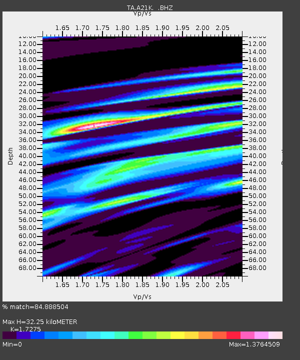
| Estimated Moho Depth: |
32.25 km |
| Estimated Crust Vp/Vs: |
1.73 |
| Assumed Crust Vp: |
6.048 km/s |
| Estimated Crust Vs: |
3.501 km/s |
| Estimated Crust Poisson's Ratio: |
0.25 |
|
| Radial Match: |
84.888504 % |
| Radial Bump: |
400 |
| Transverse Match: |
85.18922 % |
| Transverse Bump: |
356 |
| SOD ConfigId: |
818264 |
| Insert Time: |
2014-12-01 01:27:36.759 +0000 |
| GWidth: |
2.5 |
| Max Bumps: |
400 |
| Tol: |
0.001 |
|
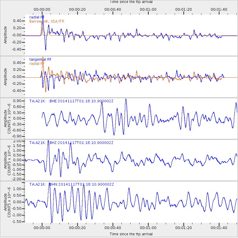
Signal To Noise
| Channel | StoN | STA | LTA |
| TA:A21K: :BHZ:20141117T01:18:10.900002Z | 10.976919 | 9.640756E-7 | 8.782752E-8 |
| TA:A21K: :BHN:20141117T01:18:10.900002Z | 3.5965953 | 5.897331E-7 | 1.6396983E-7 |
| TA:A21K: :BHE:20141117T01:18:10.900002Z | 1.844067 | 3.6059933E-7 | 1.9554568E-7 |
| Arrivals |
| Ps | 4.0 SECOND |
| PpPs | 14 SECOND |
| PsPs/PpSs | 18 SECOND |


