You are here: Home > Network List > TA - USArray Transportable Network (new EarthScope stations) Stations List
> Station I23K Minto, Yukon-Koyukuk, AK, USA > Earthquake Result Viewer
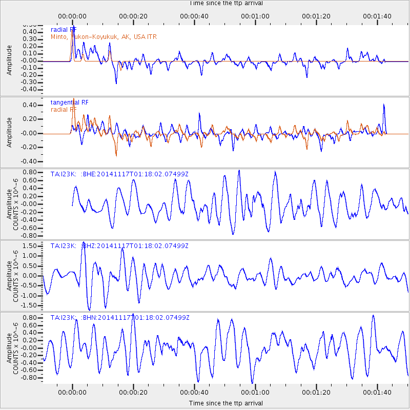
I23K Minto, Yukon-Koyukuk, AK, USA - Earthquake Result Viewer
*The percent match for this event was below the threshold and hence no stack was calculated.
| Earthquake location: |
D'Entrecasteaux Islands Region |
| Earthquake latitude/longitude: |
-9.6/155.2 |
| Earthquake time(UTC): |
2014/11/17 (321) 01:06:00 GMT |
| Earthquake Depth: |
25 km |
| Earthquake Magnitude: |
6.1 MWP |
| Earthquake Catalog/Contributor: |
NEIC PDE/NEIC COMCAT |
|
| Network: |
TA USArray Transportable Network (new EarthScope stations) |
| Station: |
I23K Minto, Yukon-Koyukuk, AK, USA |
| Lat/Lon: |
65.15 N/149.36 W |
| Elevation: |
149 m |
|
| Distance: |
85.0 deg |
| Az: |
20.46 deg |
| Baz: |
234.668 deg |
| Ray Param: |
$rayparam |
*The percent match for this event was below the threshold and hence was not used in the summary stack. |
|
| Radial Match: |
76.53594 % |
| Radial Bump: |
400 |
| Transverse Match: |
60.176285 % |
| Transverse Bump: |
400 |
| SOD ConfigId: |
818264 |
| Insert Time: |
2014-12-01 01:27:46.793 +0000 |
| GWidth: |
2.5 |
| Max Bumps: |
400 |
| Tol: |
0.001 |
|
Signal To Noise
| Channel | StoN | STA | LTA |
| TA:I23K: :BHZ:20141117T01:18:02.07499Z | 1.9382001 | 7.843765E-7 | 4.0469325E-7 |
| TA:I23K: :BHN:20141117T01:18:02.07499Z | 1.5386635 | 3.8227392E-7 | 2.4844542E-7 |
| TA:I23K: :BHE:20141117T01:18:02.07499Z | 1.1714356 | 3.1376598E-7 | 2.678474E-7 |
| Arrivals |
| Ps | |
| PpPs | |
| PsPs/PpSs | |


