You are here: Home > Network List > IU - Global Seismograph Network (GSN - IRIS/USGS) Stations List
> Station YAK Yakutsk, Russia > Earthquake Result Viewer
YAK Yakutsk, Russia - Earthquake Result Viewer
| Earthquake location: |
Sunda Strait, Indonesia |
| Earthquake latitude/longitude: |
-6.6/105.5 |
| Earthquake time(UTC): |
1997/03/17 (076) 08:05:48 GMT |
| Earthquake Depth: |
33 km |
| Earthquake Magnitude: |
5.8 MB, 6.2 MS, 6.4 UNKNOWN, 6.3 MW |
| Earthquake Catalog/Contributor: |
WHDF/NEIC |
|
| Network: |
IU Global Seismograph Network (GSN - IRIS/USGS) |
| Station: |
YAK Yakutsk, Russia |
| Lat/Lon: |
62.03 N/129.68 E |
| Elevation: |
110 m |
|
| Distance: |
70.9 deg |
| Az: |
11.782 deg |
| Baz: |
205.484 deg |
| Ray Param: |
0.054594297 |
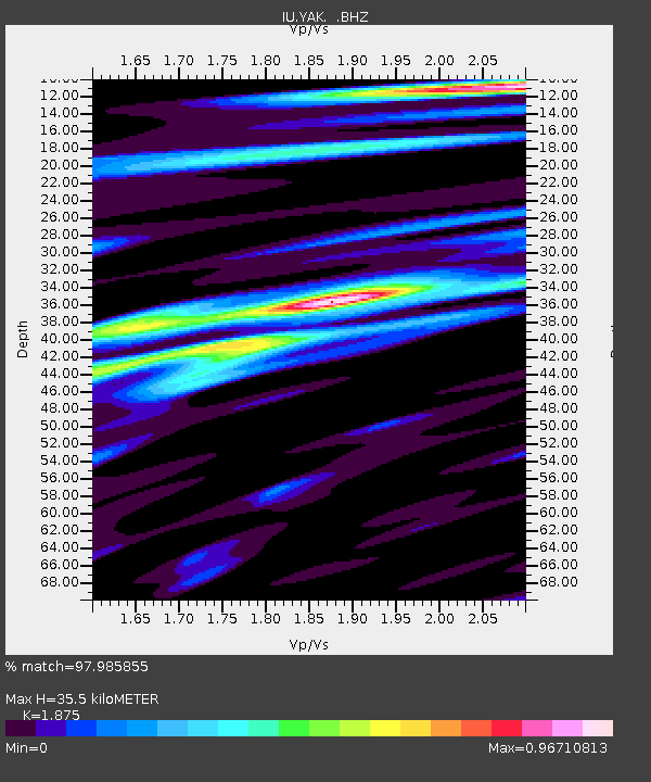
| Estimated Moho Depth: |
35.5 km |
| Estimated Crust Vp/Vs: |
1.88 |
| Assumed Crust Vp: |
6.273 km/s |
| Estimated Crust Vs: |
3.346 km/s |
| Estimated Crust Poisson's Ratio: |
0.30 |
|
| Radial Match: |
97.985855 % |
| Radial Bump: |
251 |
| Transverse Match: |
94.05434 % |
| Transverse Bump: |
400 |
| SOD ConfigId: |
4480 |
| Insert Time: |
2010-03-02 14:21:24.656 +0000 |
| GWidth: |
2.5 |
| Max Bumps: |
400 |
| Tol: |
0.001 |
|
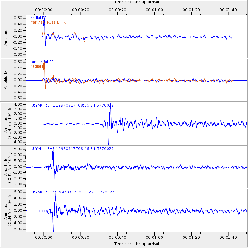
Signal To Noise
| Channel | StoN | STA | LTA |
| IU:YAK: :BHZ:19970317T08:16:31.577002Z | 29.97985 | 2.8850602E-6 | 9.623331E-8 |
| IU:YAK: :BHN:19970317T08:16:31.577002Z | 10.30435 | 5.3832724E-7 | 5.2242715E-8 |
| IU:YAK: :BHE:19970317T08:16:31.577002Z | 6.2402735 | 3.7204023E-7 | 5.961922E-8 |
| Arrivals |
| Ps | 5.1 SECOND |
| PpPs | 16 SECOND |
| PsPs/PpSs | 21 SECOND |


