You are here: Home > Network List > TA - USArray Transportable Network (new EarthScope stations) Stations List
> Station D04E Lakebay, WA, USA > Earthquake Result Viewer
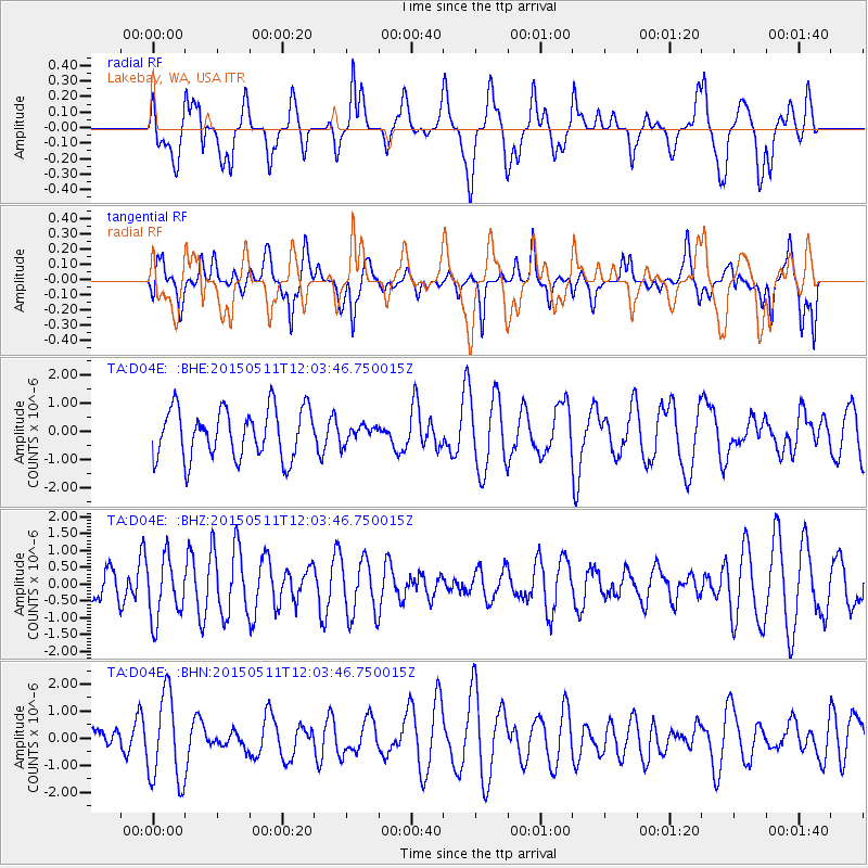
D04E Lakebay, WA, USA - Earthquake Result Viewer
*The percent match for this event was below the threshold and hence no stack was calculated.
| Earthquake location: |
Solomon Islands |
| Earthquake latitude/longitude: |
-7.2/154.4 |
| Earthquake time(UTC): |
2015/05/11 (131) 11:51:20 GMT |
| Earthquake Depth: |
39 km |
| Earthquake Magnitude: |
5.5 MB |
| Earthquake Catalog/Contributor: |
NEIC PDE/NEIC COMCAT |
|
| Network: |
TA USArray Transportable Network (new EarthScope stations) |
| Station: |
D04E Lakebay, WA, USA |
| Lat/Lon: |
47.18 N/122.77 W |
| Elevation: |
45 m |
|
| Distance: |
90.4 deg |
| Az: |
42.601 deg |
| Baz: |
259.892 deg |
| Ray Param: |
$rayparam |
*The percent match for this event was below the threshold and hence was not used in the summary stack. |
|
| Radial Match: |
51.5051 % |
| Radial Bump: |
400 |
| Transverse Match: |
54.89838 % |
| Transverse Bump: |
400 |
| SOD ConfigId: |
7422571 |
| Insert Time: |
2019-04-18 19:45:33.130 +0000 |
| GWidth: |
2.5 |
| Max Bumps: |
400 |
| Tol: |
0.001 |
|
Signal To Noise
| Channel | StoN | STA | LTA |
| TA:D04E: :BHZ:20150511T12:03:46.750015Z | 1.7755013 | 9.1529813E-7 | 5.1551535E-7 |
| TA:D04E: :BHN:20150511T12:03:46.750015Z | 3.3214626 | 1.6435923E-6 | 4.948399E-7 |
| TA:D04E: :BHE:20150511T12:03:46.750015Z | 0.34132668 | 3.0110294E-7 | 8.821547E-7 |
| Arrivals |
| Ps | |
| PpPs | |
| PsPs/PpSs | |


