You are here: Home > Network List > TA - USArray Transportable Network (new EarthScope stations) Stations List
> Station O03E Paynes Creek, CA, USA > Earthquake Result Viewer
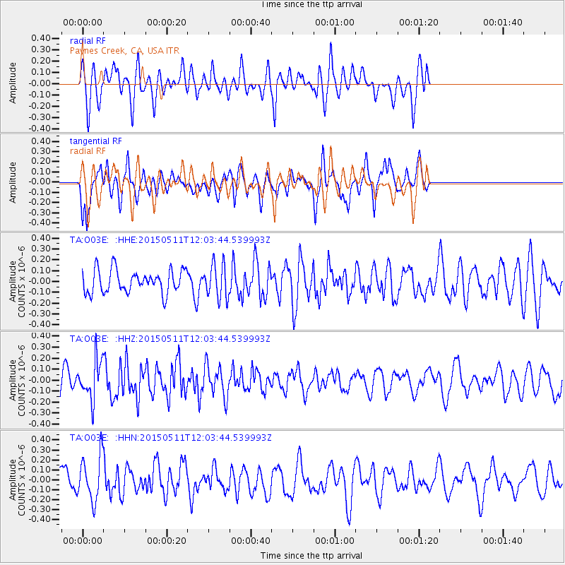
O03E Paynes Creek, CA, USA - Earthquake Result Viewer
*The percent match for this event was below the threshold and hence no stack was calculated.
| Earthquake location: |
Solomon Islands |
| Earthquake latitude/longitude: |
-7.2/154.4 |
| Earthquake time(UTC): |
2015/05/11 (131) 11:51:20 GMT |
| Earthquake Depth: |
39 km |
| Earthquake Magnitude: |
5.5 MB |
| Earthquake Catalog/Contributor: |
NEIC PDE/NEIC COMCAT |
|
| Network: |
TA USArray Transportable Network (new EarthScope stations) |
| Station: |
O03E Paynes Creek, CA, USA |
| Lat/Lon: |
40.29 N/121.80 W |
| Elevation: |
967 m |
|
| Distance: |
89.9 deg |
| Az: |
49.502 deg |
| Baz: |
260.54 deg |
| Ray Param: |
$rayparam |
*The percent match for this event was below the threshold and hence was not used in the summary stack. |
|
| Radial Match: |
48.380238 % |
| Radial Bump: |
388 |
| Transverse Match: |
64.83565 % |
| Transverse Bump: |
362 |
| SOD ConfigId: |
7422571 |
| Insert Time: |
2019-04-18 19:45:40.383 +0000 |
| GWidth: |
2.5 |
| Max Bumps: |
400 |
| Tol: |
0.001 |
|
Signal To Noise
| Channel | StoN | STA | LTA |
| TA:O03E: :HHZ:20150511T12:03:44.539993Z | 2.3718214 | 1.776852E-7 | 7.491508E-8 |
| TA:O03E: :HHN:20150511T12:03:44.539993Z | 1.676293 | 2.2693398E-7 | 1.3537846E-7 |
| TA:O03E: :HHE:20150511T12:03:44.539993Z | 1.503122 | 1.5794049E-7 | 1.0507496E-7 |
| Arrivals |
| Ps | |
| PpPs | |
| PsPs/PpSs | |


