You are here: Home > Network List > TA - USArray Transportable Network (new EarthScope stations) Stations List
> Station R11A Troy Canyon, Currant, NV, USA > Earthquake Result Viewer
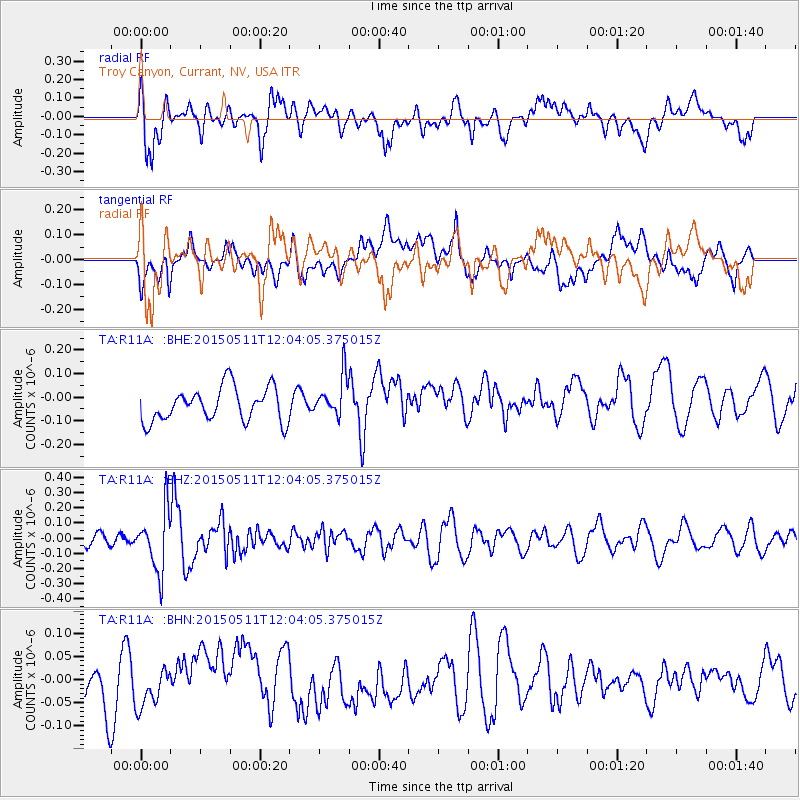
R11A Troy Canyon, Currant, NV, USA - Earthquake Result Viewer
*The percent match for this event was below the threshold and hence no stack was calculated.
| Earthquake location: |
Solomon Islands |
| Earthquake latitude/longitude: |
-7.2/154.4 |
| Earthquake time(UTC): |
2015/05/11 (131) 11:51:20 GMT |
| Earthquake Depth: |
39 km |
| Earthquake Magnitude: |
5.5 MB |
| Earthquake Catalog/Contributor: |
NEIC PDE/NEIC COMCAT |
|
| Network: |
TA USArray Transportable Network (new EarthScope stations) |
| Station: |
R11A Troy Canyon, Currant, NV, USA |
| Lat/Lon: |
38.35 N/115.59 W |
| Elevation: |
1756 m |
|
| Distance: |
94.5 deg |
| Az: |
52.06 deg |
| Baz: |
264.369 deg |
| Ray Param: |
$rayparam |
*The percent match for this event was below the threshold and hence was not used in the summary stack. |
|
| Radial Match: |
63.383053 % |
| Radial Bump: |
400 |
| Transverse Match: |
50.659355 % |
| Transverse Bump: |
400 |
| SOD ConfigId: |
7422571 |
| Insert Time: |
2019-04-18 19:45:41.694 +0000 |
| GWidth: |
2.5 |
| Max Bumps: |
400 |
| Tol: |
0.001 |
|
Signal To Noise
| Channel | StoN | STA | LTA |
| TA:R11A: :BHZ:20150511T12:04:05.375015Z | 3.9143953 | 1.982734E-7 | 5.0652368E-8 |
| TA:R11A: :BHN:20150511T12:04:05.375015Z | 0.6357334 | 3.635455E-8 | 5.7185208E-8 |
| TA:R11A: :BHE:20150511T12:04:05.375015Z | 1.1897471 | 8.474172E-8 | 7.1226665E-8 |
| Arrivals |
| Ps | |
| PpPs | |
| PsPs/PpSs | |


