You are here: Home > Network List > JP - Japan Meteorological Agency Seismic Network Stations List
> Station JMM Miyagi Marumori > Earthquake Result Viewer
JMM Miyagi Marumori - Earthquake Result Viewer
| Earthquake location: |
Northern Molucca Sea |
| Earthquake latitude/longitude: |
1.9/126.5 |
| Earthquake time(UTC): |
2014/11/18 (322) 04:47:20 GMT |
| Earthquake Depth: |
65 km |
| Earthquake Magnitude: |
5.9 MB, 5.9 MWB |
| Earthquake Catalog/Contributor: |
NEIC PDE/NEIC COMCAT |
|
| Network: |
JP Japan Meteorological Agency Seismic Network |
| Station: |
JMM Miyagi Marumori |
| Lat/Lon: |
37.87 N/140.79 E |
| Elevation: |
100 m |
|
| Distance: |
38.2 deg |
| Az: |
18.428 deg |
| Baz: |
203.53 deg |
| Ray Param: |
0.07552445 |
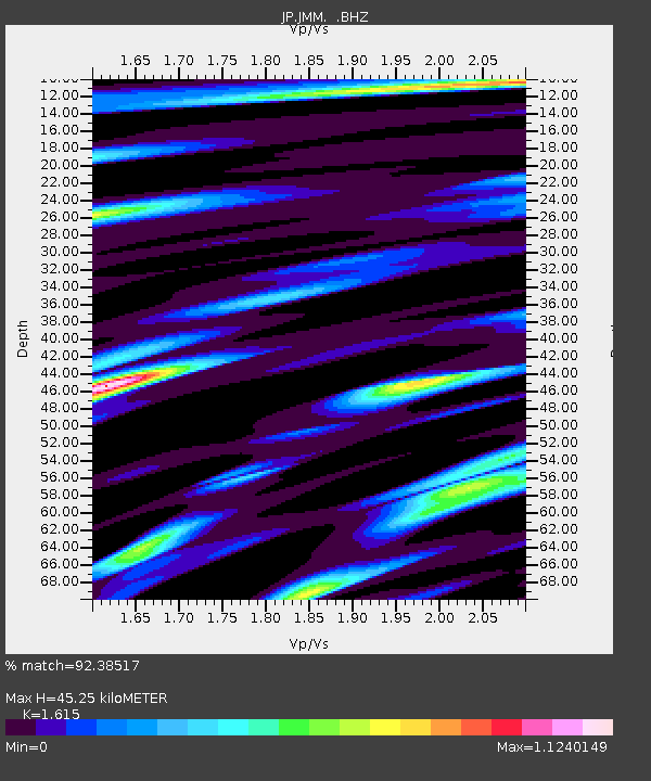
| Estimated Moho Depth: |
45.25 km |
| Estimated Crust Vp/Vs: |
1.62 |
| Assumed Crust Vp: |
6.24 km/s |
| Estimated Crust Vs: |
3.864 km/s |
| Estimated Crust Poisson's Ratio: |
0.19 |
|
| Radial Match: |
92.38517 % |
| Radial Bump: |
384 |
| Transverse Match: |
84.340294 % |
| Transverse Bump: |
400 |
| SOD ConfigId: |
818500 |
| Insert Time: |
2014-12-02 05:03:11.473 +0000 |
| GWidth: |
2.5 |
| Max Bumps: |
400 |
| Tol: |
0.001 |
|

Signal To Noise
| Channel | StoN | STA | LTA |
| JP:JMM: :BHZ:20141118T04:54:03.149985Z | 16.951044 | 4.162266E-6 | 2.455463E-7 |
| JP:JMM: :BHN:20141118T04:54:03.149985Z | 8.054447 | 2.334175E-6 | 2.8979952E-7 |
| JP:JMM: :BHE:20141118T04:54:03.149985Z | 3.5243702 | 1.1065856E-6 | 3.139811E-7 |
| Arrivals |
| Ps | 4.8 SECOND |
| PpPs | 18 SECOND |
| PsPs/PpSs | 22 SECOND |


