You are here: Home > Network List > TA - USArray Transportable Network (new EarthScope stations) Stations List
> Station A21K Barrow, AK, USA > Earthquake Result Viewer
A21K Barrow, AK, USA - Earthquake Result Viewer
| Earthquake location: |
Northern Molucca Sea |
| Earthquake latitude/longitude: |
1.9/126.5 |
| Earthquake time(UTC): |
2014/11/18 (322) 04:47:20 GMT |
| Earthquake Depth: |
65 km |
| Earthquake Magnitude: |
5.9 MB, 5.9 MWB |
| Earthquake Catalog/Contributor: |
NEIC PDE/NEIC COMCAT |
|
| Network: |
TA USArray Transportable Network (new EarthScope stations) |
| Station: |
A21K Barrow, AK, USA |
| Lat/Lon: |
71.32 N/156.62 W |
| Elevation: |
577 m |
|
| Distance: |
84.1 deg |
| Az: |
18.389 deg |
| Baz: |
258.144 deg |
| Ray Param: |
0.045625873 |
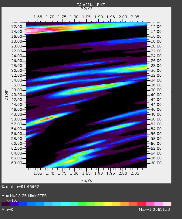
| Estimated Moho Depth: |
13.25 km |
| Estimated Crust Vp/Vs: |
1.60 |
| Assumed Crust Vp: |
6.048 km/s |
| Estimated Crust Vs: |
3.78 km/s |
| Estimated Crust Poisson's Ratio: |
0.18 |
|
| Radial Match: |
91.66662 % |
| Radial Bump: |
400 |
| Transverse Match: |
86.032135 % |
| Transverse Bump: |
400 |
| SOD ConfigId: |
818500 |
| Insert Time: |
2014-12-02 05:06:19.274 +0000 |
| GWidth: |
2.5 |
| Max Bumps: |
400 |
| Tol: |
0.001 |
|
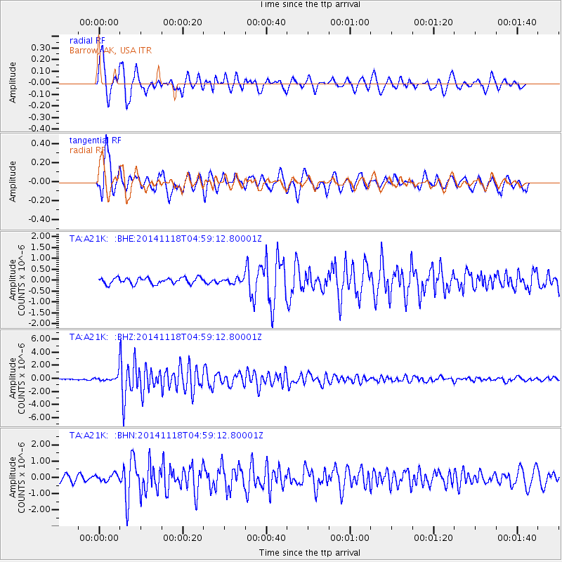
Signal To Noise
| Channel | StoN | STA | LTA |
| TA:A21K: :BHZ:20141118T04:59:12.80001Z | 6.650603 | 6.079069E-7 | 9.1406285E-8 |
| TA:A21K: :BHN:20141118T04:59:12.80001Z | 0.9563706 | 2.1584907E-7 | 2.2569606E-7 |
| TA:A21K: :BHE:20141118T04:59:12.80001Z | 0.7496351 | 1.0639893E-7 | 1.419343E-7 |
| Arrivals |
| Ps | 1.3 SECOND |
| PpPs | 5.6 SECOND |
| PsPs/PpSs | 6.9 SECOND |


