You are here: Home > Network List > TA - USArray Transportable Network (new EarthScope stations) Stations List
> Station I23K Minto, Yukon-Koyukuk, AK, USA > Earthquake Result Viewer
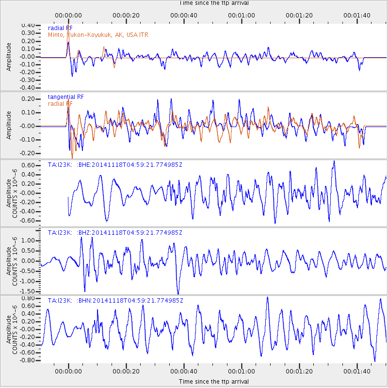
I23K Minto, Yukon-Koyukuk, AK, USA - Earthquake Result Viewer
*The percent match for this event was below the threshold and hence no stack was calculated.
| Earthquake location: |
Northern Molucca Sea |
| Earthquake latitude/longitude: |
1.9/126.5 |
| Earthquake time(UTC): |
2014/11/18 (322) 04:47:20 GMT |
| Earthquake Depth: |
65 km |
| Earthquake Magnitude: |
5.9 MB, 5.9 MWB |
| Earthquake Catalog/Contributor: |
NEIC PDE/NEIC COMCAT |
|
| Network: |
TA USArray Transportable Network (new EarthScope stations) |
| Station: |
I23K Minto, Yukon-Koyukuk, AK, USA |
| Lat/Lon: |
65.15 N/149.36 W |
| Elevation: |
149 m |
|
| Distance: |
85.9 deg |
| Az: |
24.929 deg |
| Baz: |
265.463 deg |
| Ray Param: |
$rayparam |
*The percent match for this event was below the threshold and hence was not used in the summary stack. |
|
| Radial Match: |
56.809414 % |
| Radial Bump: |
400 |
| Transverse Match: |
44.68041 % |
| Transverse Bump: |
400 |
| SOD ConfigId: |
818500 |
| Insert Time: |
2014-12-02 05:06:30.467 +0000 |
| GWidth: |
2.5 |
| Max Bumps: |
400 |
| Tol: |
0.001 |
|
Signal To Noise
| Channel | StoN | STA | LTA |
| TA:I23K: :BHZ:20141118T04:59:21.774985Z | 2.7507846 | 3.83865E-7 | 1.3954745E-7 |
| TA:I23K: :BHN:20141118T04:59:21.774985Z | 0.46200112 | 1.3780237E-7 | 2.9827282E-7 |
| TA:I23K: :BHE:20141118T04:59:21.774985Z | 0.5719383 | 1.324223E-7 | 2.315325E-7 |
| Arrivals |
| Ps | |
| PpPs | |
| PsPs/PpSs | |


