You are here: Home > Network List > G - GEOSCOPE Stations List
> Station TAM Tamanrasset, Algeria > Earthquake Result Viewer
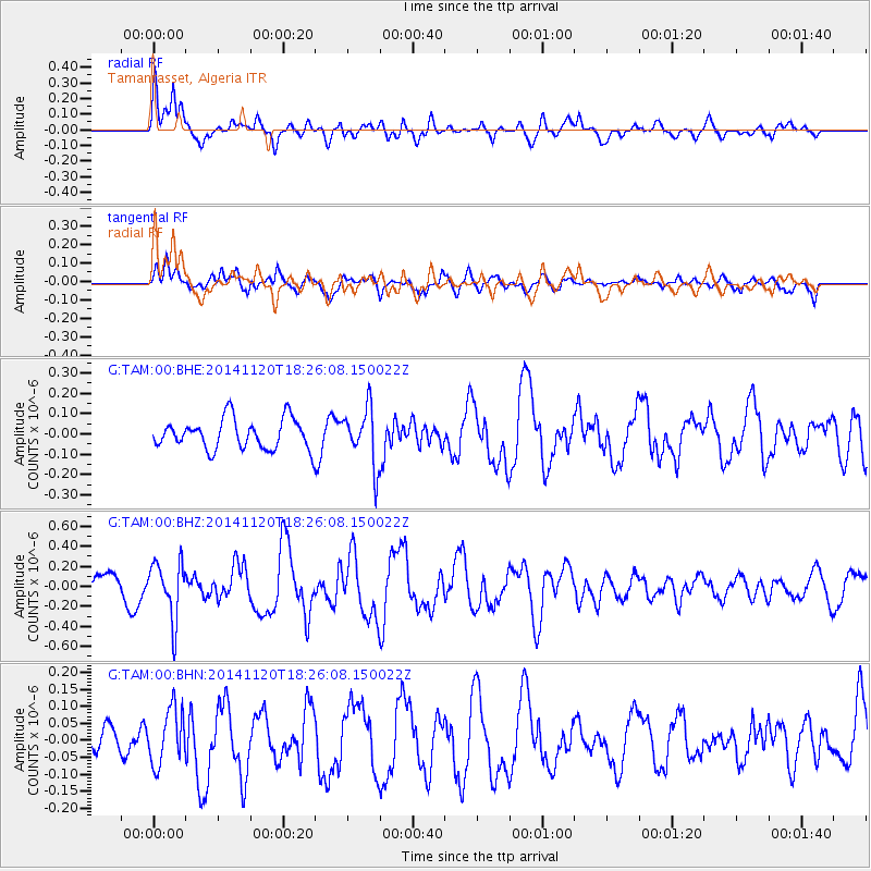
TAM Tamanrasset, Algeria - Earthquake Result Viewer
*The percent match for this event was below the threshold and hence no stack was calculated.
| Earthquake location: |
Myanmar-India Border Region |
| Earthquake latitude/longitude: |
23.5/93.5 |
| Earthquake time(UTC): |
2014/11/20 (324) 18:14:37 GMT |
| Earthquake Depth: |
48 km |
| Earthquake Magnitude: |
5.6 MWB |
| Earthquake Catalog/Contributor: |
NEIC PDE/NEIC COMCAT |
|
| Network: |
G GEOSCOPE |
| Station: |
TAM Tamanrasset, Algeria |
| Lat/Lon: |
22.79 N/5.53 E |
| Elevation: |
1377 m |
|
| Distance: |
79.5 deg |
| Az: |
290.276 deg |
| Baz: |
68.912 deg |
| Ray Param: |
$rayparam |
*The percent match for this event was below the threshold and hence was not used in the summary stack. |
|
| Radial Match: |
70.04012 % |
| Radial Bump: |
400 |
| Transverse Match: |
64.94701 % |
| Transverse Bump: |
400 |
| SOD ConfigId: |
818775 |
| Insert Time: |
2014-12-04 18:31:20.037 +0000 |
| GWidth: |
2.5 |
| Max Bumps: |
400 |
| Tol: |
0.001 |
|
Signal To Noise
| Channel | StoN | STA | LTA |
| G:TAM:00:BHZ:20141120T18:26:08.150022Z | 2.8555088 | 2.84529E-7 | 9.9642136E-8 |
| G:TAM:00:BHN:20141120T18:26:08.150022Z | 0.9300117 | 8.140003E-8 | 8.752581E-8 |
| G:TAM:00:BHE:20141120T18:26:08.150022Z | 1.8955222 | 1.3987506E-7 | 7.3792364E-8 |
| Arrivals |
| Ps | |
| PpPs | |
| PsPs/PpSs | |


