You are here: Home > Network List > UW - Pacific Northwest Regional Seismic Network Stations List
> Station HOOD Mt Hood Meadows, OR CREST BB SMO > Earthquake Result Viewer
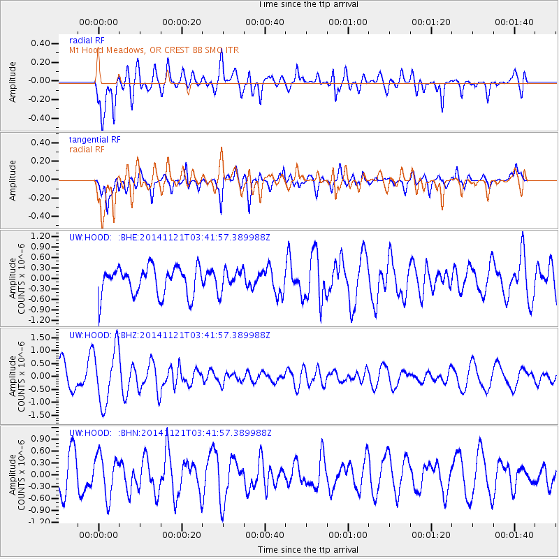
HOOD Mt Hood Meadows, OR CREST BB SMO - Earthquake Result Viewer
*The percent match for this event was below the threshold and hence no stack was calculated.
| Earthquake location: |
Philippine Islands Region |
| Earthquake latitude/longitude: |
20.7/120.0 |
| Earthquake time(UTC): |
2014/11/21 (325) 03:29:12 GMT |
| Earthquake Depth: |
10 km |
| Earthquake Magnitude: |
5.9 MWP |
| Earthquake Catalog/Contributor: |
NEIC PDE/NEIC COMCAT |
|
| Network: |
UW Pacific Northwest Regional Seismic Network |
| Station: |
HOOD Mt Hood Meadows, OR CREST BB SMO |
| Lat/Lon: |
45.32 N/121.65 W |
| Elevation: |
1520 m |
|
| Distance: |
93.7 deg |
| Az: |
38.495 deg |
| Baz: |
304.299 deg |
| Ray Param: |
$rayparam |
*The percent match for this event was below the threshold and hence was not used in the summary stack. |
|
| Radial Match: |
63.69155 % |
| Radial Bump: |
400 |
| Transverse Match: |
52.212994 % |
| Transverse Bump: |
400 |
| SOD ConfigId: |
818962 |
| Insert Time: |
2014-12-05 03:54:05.439 +0000 |
| GWidth: |
2.5 |
| Max Bumps: |
400 |
| Tol: |
0.001 |
|
Signal To Noise
| Channel | StoN | STA | LTA |
| UW:HOOD: :BHZ:20141121T03:41:57.389988Z | 2.5291953 | 1.0636953E-6 | 4.205667E-7 |
| UW:HOOD: :BHN:20141121T03:41:57.389988Z | 1.0940614 | 5.277748E-7 | 4.823996E-7 |
| UW:HOOD: :BHE:20141121T03:41:57.389988Z | 0.7479589 | 3.012992E-7 | 4.0282856E-7 |
| Arrivals |
| Ps | |
| PpPs | |
| PsPs/PpSs | |


