You are here: Home > Network List > G - GEOSCOPE Stations List
> Station NOUC Port Laguerre, New Caledonia > Earthquake Result Viewer
NOUC Port Laguerre, New Caledonia - Earthquake Result Viewer
| Earthquake location: |
Northern Molucca Sea |
| Earthquake latitude/longitude: |
2.3/127.1 |
| Earthquake time(UTC): |
2014/11/21 (325) 10:10:19 GMT |
| Earthquake Depth: |
38 km |
| Earthquake Magnitude: |
6.5 MWC, 6.8 MI, 6.9 MI |
| Earthquake Catalog/Contributor: |
NEIC PDE/NEIC COMCAT |
|
| Network: |
G GEOSCOPE |
| Station: |
NOUC Port Laguerre, New Caledonia |
| Lat/Lon: |
22.10 S/166.30 E |
| Elevation: |
112 m |
|
| Distance: |
45.3 deg |
| Az: |
124.425 deg |
| Baz: |
297.283 deg |
| Ray Param: |
0.071254335 |
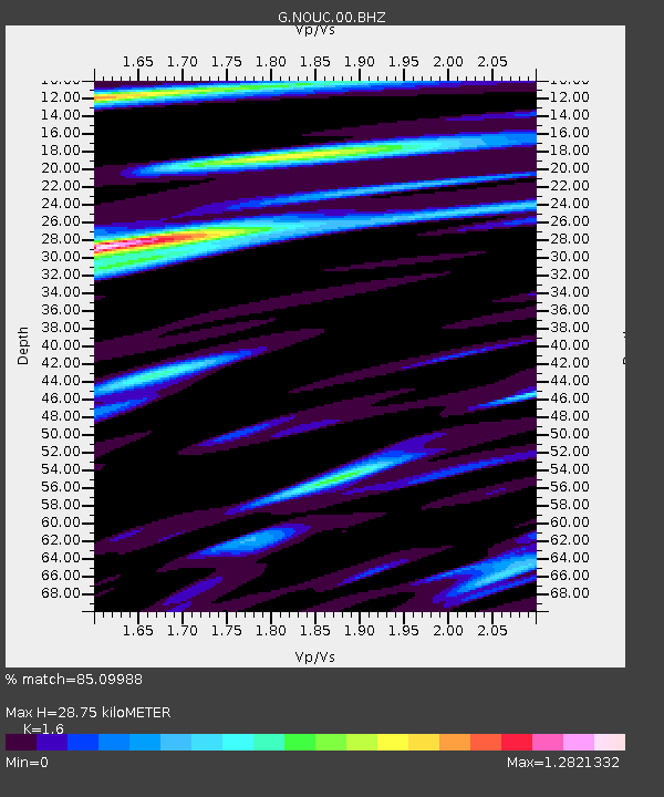
| Estimated Moho Depth: |
28.75 km |
| Estimated Crust Vp/Vs: |
1.60 |
| Assumed Crust Vp: |
5.14 km/s |
| Estimated Crust Vs: |
3.212 km/s |
| Estimated Crust Poisson's Ratio: |
0.18 |
|
| Radial Match: |
85.09988 % |
| Radial Bump: |
380 |
| Transverse Match: |
78.346245 % |
| Transverse Bump: |
400 |
| SOD ConfigId: |
819163 |
| Insert Time: |
2014-12-05 10:19:41.191 +0000 |
| GWidth: |
2.5 |
| Max Bumps: |
400 |
| Tol: |
0.001 |
|

Signal To Noise
| Channel | StoN | STA | LTA |
| G:NOUC:00:BHZ:20141121T10:18:03.799991Z | 7.0492992 | 1.9718286E-6 | 2.797198E-7 |
| G:NOUC:00:BHN:20141121T10:18:03.799991Z | 1.677575 | 4.014095E-7 | 2.3927961E-7 |
| G:NOUC:00:BHE:20141121T10:18:03.799991Z | 5.8636966 | 1.0378478E-6 | 1.7699548E-7 |
| Arrivals |
| Ps | 3.5 SECOND |
| PpPs | 14 SECOND |
| PsPs/PpSs | 17 SECOND |


