You are here: Home > Network List > IU - Global Seismograph Network (GSN - IRIS/USGS) Stations List
> Station XMAS Kiritimati Island, Republic of Kiribati > Earthquake Result Viewer
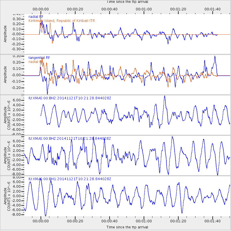
XMAS Kiritimati Island, Republic of Kiribati - Earthquake Result Viewer
*The percent match for this event was below the threshold and hence no stack was calculated.
| Earthquake location: |
Northern Molucca Sea |
| Earthquake latitude/longitude: |
2.3/127.1 |
| Earthquake time(UTC): |
2014/11/21 (325) 10:10:19 GMT |
| Earthquake Depth: |
38 km |
| Earthquake Magnitude: |
6.5 MWC, 6.8 MI, 6.9 MI |
| Earthquake Catalog/Contributor: |
NEIC PDE/NEIC COMCAT |
|
| Network: |
IU Global Seismograph Network (GSN - IRIS/USGS) |
| Station: |
XMAS Kiritimati Island, Republic of Kiribati |
| Lat/Lon: |
2.04 N/157.45 W |
| Elevation: |
20 m |
|
| Distance: |
75.4 deg |
| Az: |
88.488 deg |
| Baz: |
271.81 deg |
| Ray Param: |
$rayparam |
*The percent match for this event was below the threshold and hence was not used in the summary stack. |
|
| Radial Match: |
66.76552 % |
| Radial Bump: |
400 |
| Transverse Match: |
53.760487 % |
| Transverse Bump: |
373 |
| SOD ConfigId: |
819163 |
| Insert Time: |
2014-12-05 10:23:00.973 +0000 |
| GWidth: |
2.5 |
| Max Bumps: |
400 |
| Tol: |
0.001 |
|
Signal To Noise
| Channel | StoN | STA | LTA |
| IU:XMAS:00:BHZ:20141121T10:21:28.844028Z | 1.3480202 | 2.5422619E-6 | 1.8859225E-6 |
| IU:XMAS:00:BH1:20141121T10:21:28.844028Z | 1.8771815 | 5.4369025E-6 | 2.8963116E-6 |
| IU:XMAS:00:BH2:20141121T10:21:28.844028Z | 0.7406163 | 1.7616516E-6 | 2.378629E-6 |
| Arrivals |
| Ps | |
| PpPs | |
| PsPs/PpSs | |


