You are here: Home > Network List > KR - Kyrgyz Digital Network Stations List
> Station ARLS Aral, Kyrgyzstan > Earthquake Result Viewer
ARLS Aral, Kyrgyzstan - Earthquake Result Viewer
| Earthquake location: |
Northern Molucca Sea |
| Earthquake latitude/longitude: |
2.3/127.1 |
| Earthquake time(UTC): |
2014/11/21 (325) 10:10:19 GMT |
| Earthquake Depth: |
38 km |
| Earthquake Magnitude: |
6.5 MWC, 6.8 MI, 6.9 MI |
| Earthquake Catalog/Contributor: |
NEIC PDE/NEIC COMCAT |
|
| Network: |
KR Kyrgyz Digital Network |
| Station: |
ARLS Aral, Kyrgyzstan |
| Lat/Lon: |
41.87 N/74.33 E |
| Elevation: |
1526 m |
|
| Distance: |
61.4 deg |
| Az: |
317.412 deg |
| Baz: |
115.128 deg |
| Ray Param: |
0.06080928 |
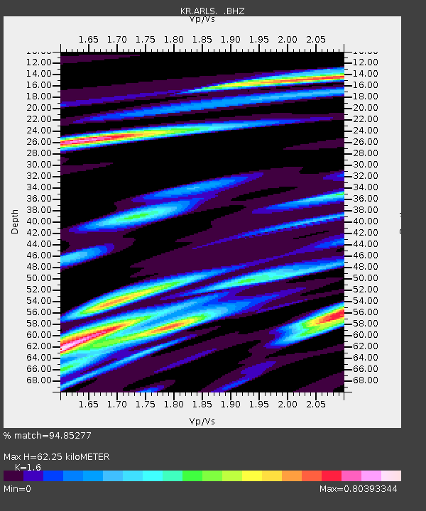
| Estimated Moho Depth: |
62.25 km |
| Estimated Crust Vp/Vs: |
1.60 |
| Assumed Crust Vp: |
6.491 km/s |
| Estimated Crust Vs: |
4.057 km/s |
| Estimated Crust Poisson's Ratio: |
0.18 |
|
| Radial Match: |
94.85277 % |
| Radial Bump: |
400 |
| Transverse Match: |
90.1076 % |
| Transverse Bump: |
400 |
| SOD ConfigId: |
819163 |
| Insert Time: |
2014-12-05 10:24:04.248 +0000 |
| GWidth: |
2.5 |
| Max Bumps: |
400 |
| Tol: |
0.001 |
|

Signal To Noise
| Channel | StoN | STA | LTA |
| KR:ARLS: :BHZ:20141121T10:20:01.574985Z | 48.809803 | 2.2750846E-6 | 4.6611223E-8 |
| KR:ARLS: :BHN:20141121T10:20:01.574985Z | 15.954328 | 6.138115E-7 | 3.847304E-8 |
| KR:ARLS: :BHE:20141121T10:20:01.574985Z | 23.050997 | 1.0439107E-6 | 4.5287013E-8 |
| Arrivals |
| Ps | 6.1 SECOND |
| PpPs | 24 SECOND |
| PsPs/PpSs | 30 SECOND |


