You are here: Home > Network List > TA - USArray Transportable Network (new EarthScope stations) Stations List
> Station A21K Barrow, AK, USA > Earthquake Result Viewer
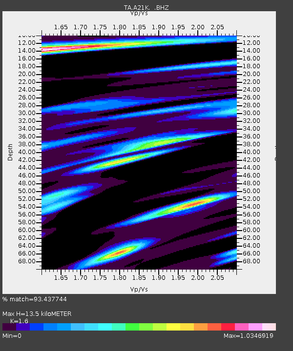
A21K Barrow, AK, USA - Earthquake Result Viewer
| Earthquake location: |
Northern Molucca Sea |
| Earthquake latitude/longitude: |
2.3/127.1 |
| Earthquake time(UTC): |
2014/11/21 (325) 10:10:19 GMT |
| Earthquake Depth: |
38 km |
| Earthquake Magnitude: |
6.5 MWC, 6.8 MI, 6.9 MI |
| Earthquake Catalog/Contributor: |
NEIC PDE/NEIC COMCAT |
|
| Network: |
TA USArray Transportable Network (new EarthScope stations) |
| Station: |
A21K Barrow, AK, USA |
| Lat/Lon: |
71.32 N/156.62 W |
| Elevation: |
577 m |
|
| Distance: |
83.5 deg |
| Az: |
18.366 deg |
| Baz: |
257.746 deg |
| Ray Param: |
0.046098053 |
| Estimated Moho Depth: |
13.5 km |
| Estimated Crust Vp/Vs: |
1.60 |
| Assumed Crust Vp: |
6.048 km/s |
| Estimated Crust Vs: |
3.78 km/s |
| Estimated Crust Poisson's Ratio: |
0.18 |
|
| Radial Match: |
93.437744 % |
| Radial Bump: |
400 |
| Transverse Match: |
91.39343 % |
| Transverse Bump: |
400 |
| SOD ConfigId: |
819163 |
| Insert Time: |
2014-12-05 10:26:48.381 +0000 |
| GWidth: |
2.5 |
| Max Bumps: |
400 |
| Tol: |
0.001 |
|

Signal To Noise
| Channel | StoN | STA | LTA |
| TA:A21K: :BHZ:20141121T10:22:12.47501Z | 14.739447 | 3.6916404E-6 | 2.504599E-7 |
| TA:A21K: :BHN:20141121T10:22:12.47501Z | 1.2825366 | 4.898871E-7 | 3.8196734E-7 |
| TA:A21K: :BHE:20141121T10:22:12.47501Z | 3.0816183 | 1.1332462E-6 | 3.6774387E-7 |
| Arrivals |
| Ps | 1.4 SECOND |
| PpPs | 5.7 SECOND |
| PsPs/PpSs | 7.0 SECOND |


