You are here: Home > Network List > TJ - Tajikistan National Seismic Network Stations List
> Station GARM Garm, Tajikistan > Earthquake Result Viewer
GARM Garm, Tajikistan - Earthquake Result Viewer
| Earthquake location: |
Northern Molucca Sea |
| Earthquake latitude/longitude: |
2.3/127.1 |
| Earthquake time(UTC): |
2014/11/21 (325) 10:10:19 GMT |
| Earthquake Depth: |
38 km |
| Earthquake Magnitude: |
6.5 MWC, 6.8 MI, 6.9 MI |
| Earthquake Catalog/Contributor: |
NEIC PDE/NEIC COMCAT |
|
| Network: |
TJ Tajikistan National Seismic Network |
| Station: |
GARM Garm, Tajikistan |
| Lat/Lon: |
39.00 N/70.32 E |
| Elevation: |
1305 m |
|
| Distance: |
63.1 deg |
| Az: |
313.086 deg |
| Baz: |
110.521 deg |
| Ray Param: |
0.059698917 |
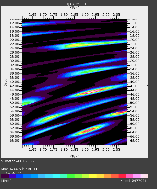
| Estimated Moho Depth: |
44.5 km |
| Estimated Crust Vp/Vs: |
1.93 |
| Assumed Crust Vp: |
6.306 km/s |
| Estimated Crust Vs: |
3.272 km/s |
| Estimated Crust Poisson's Ratio: |
0.32 |
|
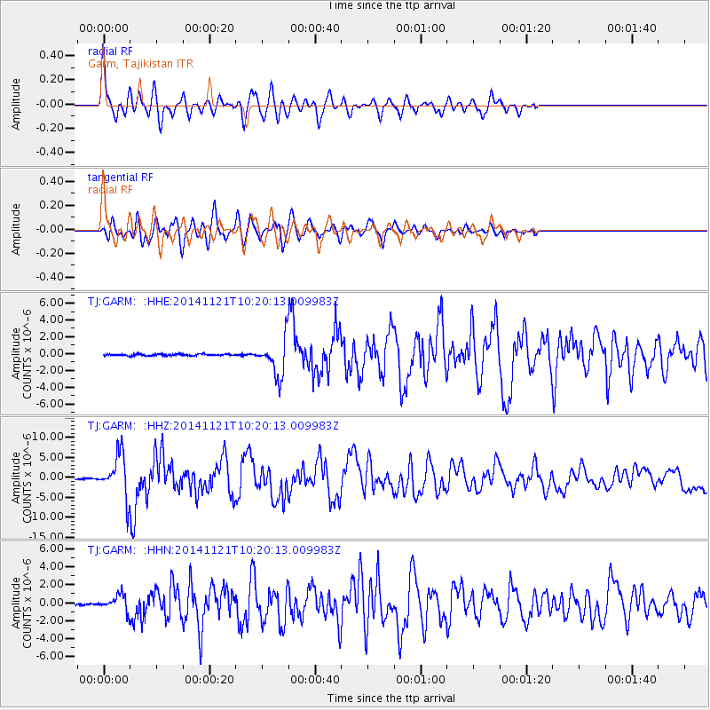
| Radial Match: |
86.62365 % |
| Radial Bump: |
400 |
| Transverse Match: |
84.34037 % |
| Transverse Bump: |
400 |
| SOD ConfigId: |
819163 |
| Insert Time: |
2014-12-05 10:27:05.219 +0000 |
| GWidth: |
2.5 |
| Max Bumps: |
400 |
| Tol: |
0.001 |
|
Signal To Noise
| Channel | StoN | STA | LTA |
| TJ:GARM: :HHZ:20141121T10:20:13.009983Z | 38.866642 | 5.3486165E-6 | 1.3761456E-7 |
| TJ:GARM: :HHN:20141121T10:20:13.009983Z | 9.806128 | 8.9175364E-7 | 9.093841E-8 |
| TJ:GARM: :HHE:20141121T10:20:13.009983Z | 24.021708 | 2.1998233E-6 | 9.1576474E-8 |
| Arrivals |
| Ps | 6.8 SECOND |
| PpPs | 20 SECOND |
| PsPs/PpSs | 27 SECOND |


