You are here: Home > Network List > AU - Australian Seismological Centre Stations List
> Station CTA Charters Towers, Queensland > Earthquake Result Viewer
CTA Charters Towers, Queensland - Earthquake Result Viewer
| Earthquake location: |
Eastern Honshu, Japan |
| Earthquake latitude/longitude: |
36.6/137.9 |
| Earthquake time(UTC): |
2014/11/22 (326) 13:08:18 GMT |
| Earthquake Depth: |
10 km |
| Earthquake Magnitude: |
6.2 MWP |
| Earthquake Catalog/Contributor: |
NEIC PDE/NEIC COMCAT |
|
| Network: |
AU Australian Seismological Centre |
| Station: |
CTA Charters Towers, Queensland |
| Lat/Lon: |
20.09 S/146.25 E |
| Elevation: |
426 m |
|
| Distance: |
57.0 deg |
| Az: |
170.642 deg |
| Baz: |
352.002 deg |
| Ray Param: |
0.06379452 |
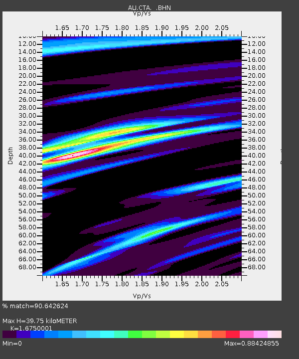
| Estimated Moho Depth: |
39.75 km |
| Estimated Crust Vp/Vs: |
1.68 |
| Assumed Crust Vp: |
6.522 km/s |
| Estimated Crust Vs: |
3.894 km/s |
| Estimated Crust Poisson's Ratio: |
0.22 |
|
| Radial Match: |
90.642624 % |
| Radial Bump: |
331 |
| Transverse Match: |
78.93788 % |
| Transverse Bump: |
399 |
| SOD ConfigId: |
819644 |
| Insert Time: |
2014-12-06 13:24:09.028 +0000 |
| GWidth: |
2.5 |
| Max Bumps: |
400 |
| Tol: |
0.001 |
|

Signal To Noise
| Channel | StoN | STA | LTA |
| AU:CTA: :BHZ:20141122T13:17:32.950002Z | 3.2749746 | 5.0486864E-7 | 1.5415957E-7 |
| AU:CTA: :BHN:20141122T13:17:32.950002Z | 2.8462298 | 3.965167E-7 | 1.3931295E-7 |
| AU:CTA: :BHE:20141122T13:17:32.950002Z | 0.7405079 | 9.7753606E-8 | 1.3200886E-7 |
| Arrivals |
| Ps | 4.3 SECOND |
| PpPs | 15 SECOND |
| PsPs/PpSs | 20 SECOND |


