You are here: Home > Network List > II - Global Seismograph Network (GSN - IRIS/IDA) Stations List
> Station NIL Nilore, Pakistan > Earthquake Result Viewer
NIL Nilore, Pakistan - Earthquake Result Viewer
| Earthquake location: |
Eastern Honshu, Japan |
| Earthquake latitude/longitude: |
36.6/137.9 |
| Earthquake time(UTC): |
2014/11/22 (326) 13:08:18 GMT |
| Earthquake Depth: |
10 km |
| Earthquake Magnitude: |
6.2 MWP |
| Earthquake Catalog/Contributor: |
NEIC PDE/NEIC COMCAT |
|
| Network: |
II Global Seismograph Network (GSN - IRIS/IDA) |
| Station: |
NIL Nilore, Pakistan |
| Lat/Lon: |
33.65 N/73.27 E |
| Elevation: |
629 m |
|
| Distance: |
52.0 deg |
| Az: |
287.062 deg |
| Baz: |
67.191 deg |
| Ray Param: |
0.06701401 |
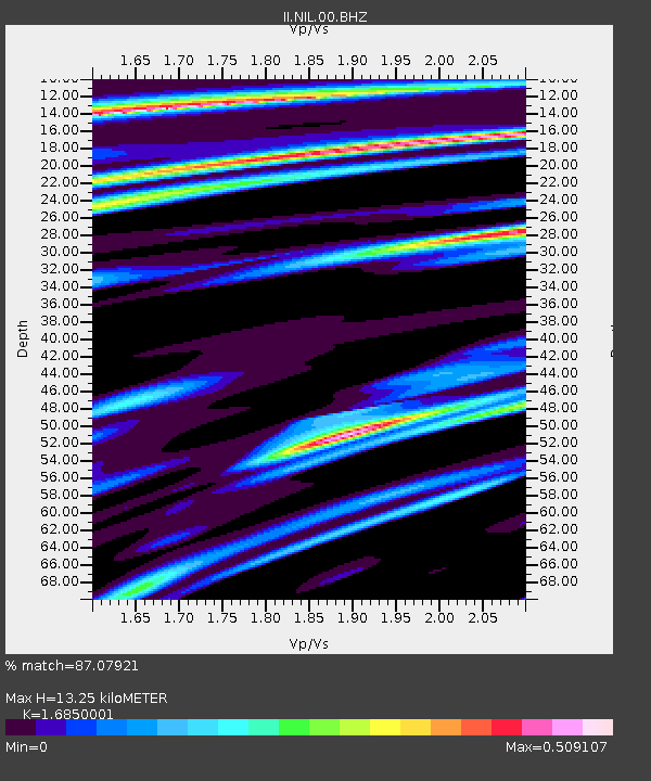
| Estimated Moho Depth: |
13.25 km |
| Estimated Crust Vp/Vs: |
1.69 |
| Assumed Crust Vp: |
6.242 km/s |
| Estimated Crust Vs: |
3.704 km/s |
| Estimated Crust Poisson's Ratio: |
0.23 |
|
| Radial Match: |
87.07921 % |
| Radial Bump: |
400 |
| Transverse Match: |
77.37097 % |
| Transverse Bump: |
400 |
| SOD ConfigId: |
819644 |
| Insert Time: |
2014-12-06 13:34:48.490 +0000 |
| GWidth: |
2.5 |
| Max Bumps: |
400 |
| Tol: |
0.001 |
|

Signal To Noise
| Channel | StoN | STA | LTA |
| II:NIL:00:BHZ:20141122T13:16:57.218984Z | 38.535122 | 2.2997021E-6 | 5.967808E-8 |
| II:NIL:00:BH1:20141122T13:16:57.218984Z | 6.3290796 | 4.2366523E-7 | 6.6939464E-8 |
| II:NIL:00:BH2:20141122T13:16:57.218984Z | 22.844198 | 9.128054E-7 | 3.9957865E-8 |
| Arrivals |
| Ps | 1.5 SECOND |
| PpPs | 5.4 SECOND |
| PsPs/PpSs | 6.9 SECOND |


