You are here: Home > Network List > KR - Kyrgyz Digital Network Stations List
> Station OHH Osh,Kyrgyzstan > Earthquake Result Viewer
OHH Osh,Kyrgyzstan - Earthquake Result Viewer
| Earthquake location: |
Eastern Honshu, Japan |
| Earthquake latitude/longitude: |
36.6/137.9 |
| Earthquake time(UTC): |
2014/11/22 (326) 13:08:18 GMT |
| Earthquake Depth: |
10 km |
| Earthquake Magnitude: |
6.2 MWP |
| Earthquake Catalog/Contributor: |
NEIC PDE/NEIC COMCAT |
|
| Network: |
KR Kyrgyz Digital Network |
| Station: |
OHH Osh,Kyrgyzstan |
| Lat/Lon: |
40.53 N/72.78 E |
| Elevation: |
800 m |
|
| Distance: |
50.0 deg |
| Az: |
295.522 deg |
| Baz: |
72.224 deg |
| Ray Param: |
0.0683277 |
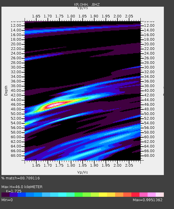
| Estimated Moho Depth: |
46.0 km |
| Estimated Crust Vp/Vs: |
1.73 |
| Assumed Crust Vp: |
6.306 km/s |
| Estimated Crust Vs: |
3.656 km/s |
| Estimated Crust Poisson's Ratio: |
0.25 |
|
| Radial Match: |
88.789116 % |
| Radial Bump: |
370 |
| Transverse Match: |
81.13832 % |
| Transverse Bump: |
400 |
| SOD ConfigId: |
819644 |
| Insert Time: |
2014-12-06 13:36:50.567 +0000 |
| GWidth: |
2.5 |
| Max Bumps: |
400 |
| Tol: |
0.001 |
|

Signal To Noise
| Channel | StoN | STA | LTA |
| KR:OHH: :BHZ:20141122T13:16:42.075002Z | 7.051445 | 1.8319802E-6 | 2.5980208E-7 |
| KR:OHH: :BHN:20141122T13:16:42.075002Z | 1.2214936 | 3.0573509E-7 | 2.502961E-7 |
| KR:OHH: :BHE:20141122T13:16:42.075002Z | 4.629015 | 9.598342E-7 | 2.0735173E-7 |
| Arrivals |
| Ps | 5.6 SECOND |
| PpPs | 19 SECOND |
| PsPs/PpSs | 24 SECOND |


