You are here: Home > Network List > TA - USArray Transportable Network (new EarthScope stations) Stations List
> Station G59A Clarenceville, QC, USA > Earthquake Result Viewer
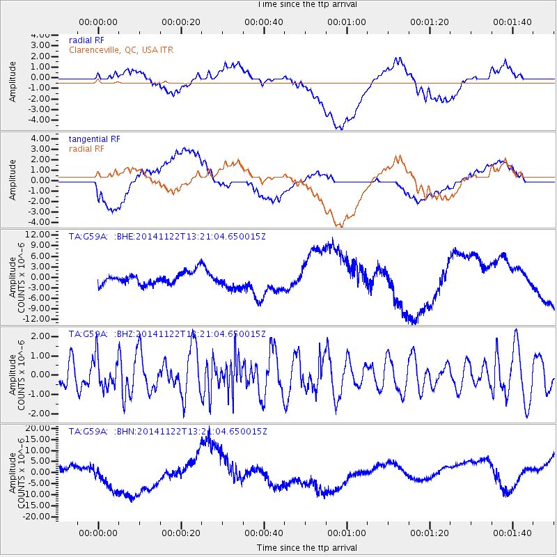
G59A Clarenceville, QC, USA - Earthquake Result Viewer
*The percent match for this event was below the threshold and hence no stack was calculated.
| Earthquake location: |
Eastern Honshu, Japan |
| Earthquake latitude/longitude: |
36.6/137.9 |
| Earthquake time(UTC): |
2014/11/22 (326) 13:08:18 GMT |
| Earthquake Depth: |
10 km |
| Earthquake Magnitude: |
6.2 MWP |
| Earthquake Catalog/Contributor: |
NEIC PDE/NEIC COMCAT |
|
| Network: |
TA USArray Transportable Network (new EarthScope stations) |
| Station: |
G59A Clarenceville, QC, USA |
| Lat/Lon: |
45.08 N/73.18 W |
| Elevation: |
36 m |
|
| Distance: |
93.9 deg |
| Az: |
21.514 deg |
| Baz: |
335.396 deg |
| Ray Param: |
$rayparam |
*The percent match for this event was below the threshold and hence was not used in the summary stack. |
|
| Radial Match: |
35.61471 % |
| Radial Bump: |
400 |
| Transverse Match: |
42.387344 % |
| Transverse Bump: |
400 |
| SOD ConfigId: |
819644 |
| Insert Time: |
2014-12-06 13:44:57.882 +0000 |
| GWidth: |
2.5 |
| Max Bumps: |
400 |
| Tol: |
0.001 |
|
Signal To Noise
| Channel | StoN | STA | LTA |
| TA:G59A: :BHZ:20141122T13:21:04.650015Z | 1.1674315 | 7.9006594E-7 | 6.7675575E-7 |
| TA:G59A: :BHN:20141122T13:21:04.650015Z | 1.5029336 | 1.418932E-5 | 9.4410825E-6 |
| TA:G59A: :BHE:20141122T13:21:04.650015Z | 1.4840835 | 2.4360859E-6 | 1.6414749E-6 |
| Arrivals |
| Ps | |
| PpPs | |
| PsPs/PpSs | |


