You are here: Home > Network List > TA - USArray Transportable Network (new EarthScope stations) Stations List
> Station I61A Oroboro, Fairlee, VT, USA > Earthquake Result Viewer
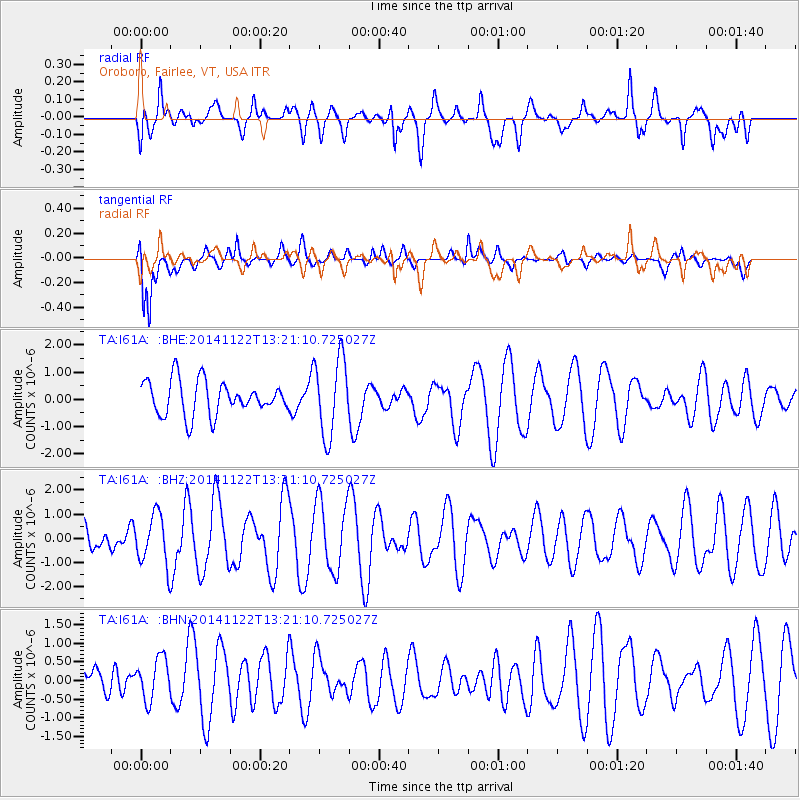
I61A Oroboro, Fairlee, VT, USA - Earthquake Result Viewer
*The percent match for this event was below the threshold and hence no stack was calculated.
| Earthquake location: |
Eastern Honshu, Japan |
| Earthquake latitude/longitude: |
36.6/137.9 |
| Earthquake time(UTC): |
2014/11/22 (326) 13:08:18 GMT |
| Earthquake Depth: |
10 km |
| Earthquake Magnitude: |
6.2 MWP |
| Earthquake Catalog/Contributor: |
NEIC PDE/NEIC COMCAT |
|
| Network: |
TA USArray Transportable Network (new EarthScope stations) |
| Station: |
I61A Oroboro, Fairlee, VT, USA |
| Lat/Lon: |
43.93 N/72.21 W |
| Elevation: |
287 m |
|
| Distance: |
95.3 deg |
| Az: |
21.351 deg |
| Baz: |
336.089 deg |
| Ray Param: |
$rayparam |
*The percent match for this event was below the threshold and hence was not used in the summary stack. |
|
| Radial Match: |
55.516415 % |
| Radial Bump: |
400 |
| Transverse Match: |
74.100685 % |
| Transverse Bump: |
400 |
| SOD ConfigId: |
819644 |
| Insert Time: |
2014-12-06 13:45:26.338 +0000 |
| GWidth: |
2.5 |
| Max Bumps: |
400 |
| Tol: |
0.001 |
|
Signal To Noise
| Channel | StoN | STA | LTA |
| TA:I61A: :BHZ:20141122T13:21:10.725027Z | 1.1613328 | 1.0373637E-6 | 8.9325266E-7 |
| TA:I61A: :BHN:20141122T13:21:10.725027Z | 0.90526175 | 5.7912024E-7 | 6.3972686E-7 |
| TA:I61A: :BHE:20141122T13:21:10.725027Z | 2.2903697 | 1.4231277E-6 | 6.213528E-7 |
| Arrivals |
| Ps | |
| PpPs | |
| PsPs/PpSs | |


