You are here: Home > Network List > TA - USArray Transportable Network (new EarthScope stations) Stations List
> Station A21K Barrow, AK, USA > Earthquake Result Viewer
A21K Barrow, AK, USA - Earthquake Result Viewer

| Earthquake location: |
Eastern Honshu, Japan |
| Earthquake latitude/longitude: |
36.6/137.9 |
| Earthquake time(UTC): |
2014/11/22 (326) 13:08:18 GMT |
| Earthquake Depth: |
10 km |
| Earthquake Magnitude: |
6.2 MWP |
| Earthquake Catalog/Contributor: |
NEIC PDE/NEIC COMCAT |
|
| Network: |
TA USArray Transportable Network (new EarthScope stations) |
| Station: |
A21K Barrow, AK, USA |
| Lat/Lon: |
71.32 N/156.62 W |
| Elevation: |
577 m |
|
| Distance: |
47.9 deg |
| Az: |
23.258 deg |
| Baz: |
260.332 deg |
| Ray Param: |
0.06968267 |
| Estimated Moho Depth: |
32.5 km |
| Estimated Crust Vp/Vs: |
1.72 |
| Assumed Crust Vp: |
6.048 km/s |
| Estimated Crust Vs: |
3.521 km/s |
| Estimated Crust Poisson's Ratio: |
0.24 |
|
| Radial Match: |
85.13352 % |
| Radial Bump: |
355 |
| Transverse Match: |
65.65198 % |
| Transverse Bump: |
396 |
| SOD ConfigId: |
819644 |
| Insert Time: |
2014-12-06 13:47:26.726 +0000 |
| GWidth: |
2.5 |
| Max Bumps: |
400 |
| Tol: |
0.001 |
|
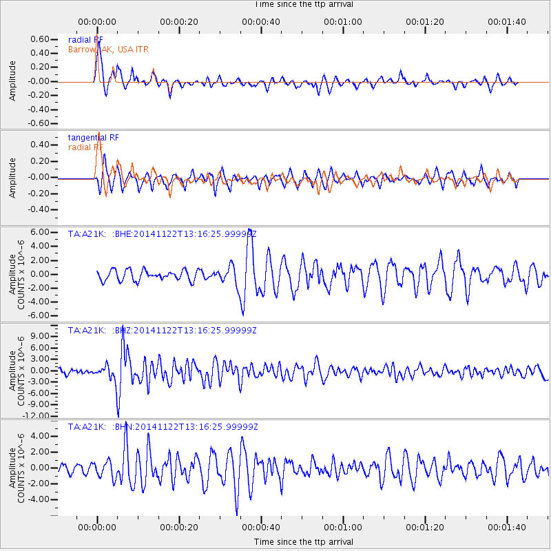
Signal To Noise
| Channel | StoN | STA | LTA |
| TA:A21K: :BHZ:20141122T13:16:25.99999Z | 3.9945354 | 2.07887E-6 | 5.2042844E-7 |
| TA:A21K: :BHN:20141122T13:16:25.99999Z | 1.1482066 | 1.0309981E-6 | 8.979203E-7 |
| TA:A21K: :BHE:20141122T13:16:25.99999Z | 1.9234738 | 1.4008251E-6 | 7.2827874E-7 |
| Arrivals |
| Ps | 4.1 SECOND |
| PpPs | 14 SECOND |
| PsPs/PpSs | 18 SECOND |


