You are here: Home > Network List > TJ - Tajikistan National Seismic Network Stations List
> Station SHAA Shaartuz, Tajikistan > Earthquake Result Viewer
SHAA Shaartuz, Tajikistan - Earthquake Result Viewer
| Earthquake location: |
Eastern Honshu, Japan |
| Earthquake latitude/longitude: |
36.6/137.9 |
| Earthquake time(UTC): |
2014/11/22 (326) 13:08:18 GMT |
| Earthquake Depth: |
10 km |
| Earthquake Magnitude: |
6.2 MWP |
| Earthquake Catalog/Contributor: |
NEIC PDE/NEIC COMCAT |
|
| Network: |
TJ Tajikistan National Seismic Network |
| Station: |
SHAA Shaartuz, Tajikistan |
| Lat/Lon: |
37.56 N/68.12 E |
| Elevation: |
868 m |
|
| Distance: |
54.4 deg |
| Az: |
293.556 deg |
| Baz: |
68.094 deg |
| Ray Param: |
0.06544587 |
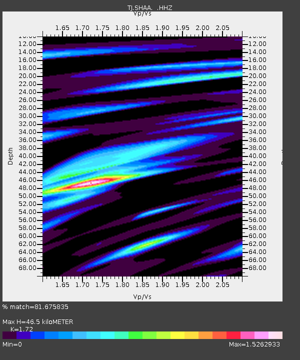
| Estimated Moho Depth: |
46.5 km |
| Estimated Crust Vp/Vs: |
1.72 |
| Assumed Crust Vp: |
6.213 km/s |
| Estimated Crust Vs: |
3.612 km/s |
| Estimated Crust Poisson's Ratio: |
0.24 |
|
| Radial Match: |
81.675835 % |
| Radial Bump: |
400 |
| Transverse Match: |
73.38659 % |
| Transverse Bump: |
400 |
| SOD ConfigId: |
819644 |
| Insert Time: |
2014-12-06 13:47:46.423 +0000 |
| GWidth: |
2.5 |
| Max Bumps: |
400 |
| Tol: |
0.001 |
|
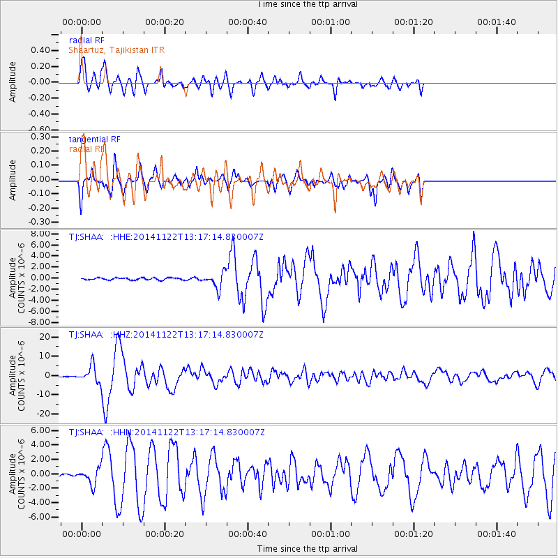
Signal To Noise
| Channel | StoN | STA | LTA |
| TJ:SHAA: :HHZ:20141122T13:17:14.830007Z | 37.724777 | 4.5629113E-6 | 1.2095263E-7 |
| TJ:SHAA: :HHN:20141122T13:17:14.830007Z | 7.4800925 | 1.1541613E-6 | 1.5429772E-7 |
| TJ:SHAA: :HHE:20141122T13:17:14.830007Z | 8.071667 | 1.4779462E-6 | 1.8310297E-7 |
| Arrivals |
| Ps | 5.7 SECOND |
| PpPs | 19 SECOND |
| PsPs/PpSs | 25 SECOND |


