You are here: Home > Network List > AK - Alaska Regional Network Stations List
> Station MDM Murphy Dome > Earthquake Result Viewer
MDM Murphy Dome - Earthquake Result Viewer
| Earthquake location: |
Nepal |
| Earthquake latitude/longitude: |
27.8/86.1 |
| Earthquake time(UTC): |
2015/05/12 (132) 07:05:19 GMT |
| Earthquake Depth: |
15 km |
| Earthquake Magnitude: |
7.3 MWW |
| Earthquake Catalog/Contributor: |
NEIC PDE/NEIC COMCAT |
|
| Network: |
AK Alaska Regional Network |
| Station: |
MDM Murphy Dome |
| Lat/Lon: |
64.96 N/148.23 W |
| Elevation: |
634 m |
|
| Distance: |
78.4 deg |
| Az: |
20.66 deg |
| Baz: |
312.768 deg |
| Ray Param: |
0.04963227 |
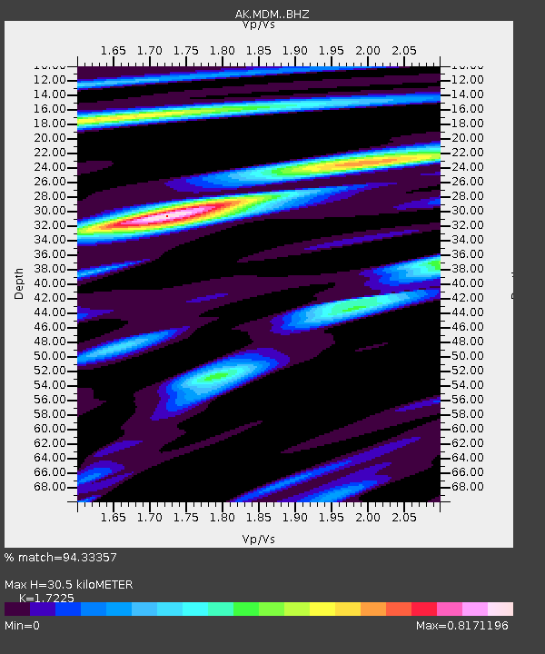
| Estimated Moho Depth: |
30.5 km |
| Estimated Crust Vp/Vs: |
1.72 |
| Assumed Crust Vp: |
6.566 km/s |
| Estimated Crust Vs: |
3.812 km/s |
| Estimated Crust Poisson's Ratio: |
0.25 |
|
| Radial Match: |
94.33357 % |
| Radial Bump: |
400 |
| Transverse Match: |
84.966545 % |
| Transverse Bump: |
400 |
| SOD ConfigId: |
7422571 |
| Insert Time: |
2019-04-18 20:08:58.698 +0000 |
| GWidth: |
2.5 |
| Max Bumps: |
400 |
| Tol: |
0.001 |
|

Signal To Noise
| Channel | StoN | STA | LTA |
| AK:MDM: :BHZ:20150512T07:16:48.048005Z | 49.021645 | 4.291183E-6 | 8.753649E-8 |
| AK:MDM: :BHN:20150512T07:16:48.048005Z | 8.840398 | 8.7528684E-7 | 9.9009895E-8 |
| AK:MDM: :BHE:20150512T07:16:48.048005Z | 14.034795 | 1.0829325E-6 | 7.716055E-8 |
| Arrivals |
| Ps | 3.5 SECOND |
| PpPs | 12 SECOND |
| PsPs/PpSs | 16 SECOND |


