You are here: Home > Network List > TA - USArray Transportable Network (new EarthScope stations) Stations List
> Station P56A Dayton Farm, Ripley, WV, USA > Earthquake Result Viewer
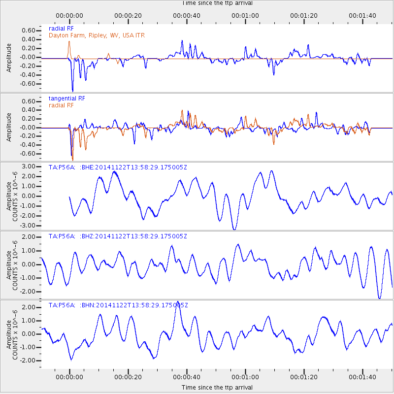
P56A Dayton Farm, Ripley, WV, USA - Earthquake Result Viewer
*The percent match for this event was below the threshold and hence no stack was calculated.
| Earthquake location: |
Hindu Kush Region, Afghanistan |
| Earthquake latitude/longitude: |
36.5/66.5 |
| Earthquake time(UTC): |
2014/11/22 (326) 13:45:27 GMT |
| Earthquake Depth: |
24 km |
| Earthquake Magnitude: |
5.5 MB |
| Earthquake Catalog/Contributor: |
NEIC PDE/NEIC COMCAT |
|
| Network: |
TA USArray Transportable Network (new EarthScope stations) |
| Station: |
P56A Dayton Farm, Ripley, WV, USA |
| Lat/Lon: |
39.50 N/78.84 W |
| Elevation: |
249 m |
|
| Distance: |
97.9 deg |
| Az: |
333.649 deg |
| Baz: |
27.532 deg |
| Ray Param: |
$rayparam |
*The percent match for this event was below the threshold and hence was not used in the summary stack. |
|
| Radial Match: |
78.88307 % |
| Radial Bump: |
305 |
| Transverse Match: |
63.643345 % |
| Transverse Bump: |
354 |
| SOD ConfigId: |
819644 |
| Insert Time: |
2014-12-06 14:03:38.716 +0000 |
| GWidth: |
2.5 |
| Max Bumps: |
400 |
| Tol: |
0.001 |
|
Signal To Noise
| Channel | StoN | STA | LTA |
| TA:P56A: :BHZ:20141122T13:58:29.175005Z | 1.1753569 | 7.862202E-7 | 6.689204E-7 |
| TA:P56A: :BHN:20141122T13:58:29.175005Z | 1.3691516 | 1.3375762E-6 | 9.76938E-7 |
| TA:P56A: :BHE:20141122T13:58:29.175005Z | 0.9912597 | 1.2411608E-6 | 1.2521047E-6 |
| Arrivals |
| Ps | |
| PpPs | |
| PsPs/PpSs | |


