You are here: Home > Network List > AV - Alaska Volcano Observatory Stations List
> Station MAPS Pakushin Southeast, Makushin Volcano, Alaska > Earthquake Result Viewer
MAPS Pakushin Southeast, Makushin Volcano, Alaska - Earthquake Result Viewer
| Earthquake location: |
Nepal |
| Earthquake latitude/longitude: |
27.8/86.1 |
| Earthquake time(UTC): |
2015/05/12 (132) 07:05:19 GMT |
| Earthquake Depth: |
15 km |
| Earthquake Magnitude: |
7.3 MWW |
| Earthquake Catalog/Contributor: |
NEIC PDE/NEIC COMCAT |
|
| Network: |
AV Alaska Volcano Observatory |
| Station: |
MAPS Pakushin Southeast, Makushin Volcano, Alaska |
| Lat/Lon: |
53.81 N/166.94 W |
| Elevation: |
333 m |
|
| Distance: |
77.3 deg |
| Az: |
35.559 deg |
| Baz: |
299.733 deg |
| Ray Param: |
0.050436597 |
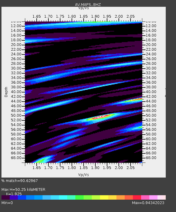
| Estimated Moho Depth: |
50.25 km |
| Estimated Crust Vp/Vs: |
1.92 |
| Assumed Crust Vp: |
3.943 km/s |
| Estimated Crust Vs: |
2.049 km/s |
| Estimated Crust Poisson's Ratio: |
0.32 |
|
| Radial Match: |
90.62967 % |
| Radial Bump: |
400 |
| Transverse Match: |
82.49719 % |
| Transverse Bump: |
400 |
| SOD ConfigId: |
7422571 |
| Insert Time: |
2019-04-18 20:10:05.329 +0000 |
| GWidth: |
2.5 |
| Max Bumps: |
400 |
| Tol: |
0.001 |
|
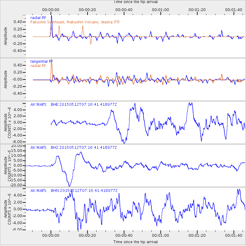
Signal To Noise
| Channel | StoN | STA | LTA |
| AV:MAPS: :BHZ:20150512T07:16:41.418977Z | 19.372368 | 5.766109E-6 | 2.9764604E-7 |
| AV:MAPS: :BHN:20150512T07:16:41.418977Z | 7.1431293 | 1.4855799E-6 | 2.0797327E-7 |
| AV:MAPS: :BHE:20150512T07:16:41.418977Z | 5.7413855 | 2.1718295E-6 | 3.7827618E-7 |
| Arrivals |
| Ps | 12 SECOND |
| PpPs | 37 SECOND |
| PsPs/PpSs | 49 SECOND |


