You are here: Home > Network List > IU - Global Seismograph Network (GSN - IRIS/USGS) Stations List
> Station CTAO Charters Towers, Australia > Earthquake Result Viewer
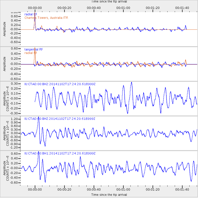
CTAO Charters Towers, Australia - Earthquake Result Viewer
*The percent match for this event was below the threshold and hence no stack was calculated.
| Earthquake location: |
Balleny Islands Region |
| Earthquake latitude/longitude: |
-61.2/154.2 |
| Earthquake time(UTC): |
2014/11/02 (306) 17:17:04 GMT |
| Earthquake Depth: |
10 km |
| Earthquake Magnitude: |
6.0 MWW, 6.0 MWC, 6.0 MWB |
| Earthquake Catalog/Contributor: |
NEIC PDE/NEIC COMCAT |
|
| Network: |
IU Global Seismograph Network (GSN - IRIS/USGS) |
| Station: |
CTAO Charters Towers, Australia |
| Lat/Lon: |
20.09 S/146.25 E |
| Elevation: |
357 m |
|
| Distance: |
41.5 deg |
| Az: |
348.694 deg |
| Baz: |
174.207 deg |
| Ray Param: |
$rayparam |
*The percent match for this event was below the threshold and hence was not used in the summary stack. |
|
| Radial Match: |
78.07929 % |
| Radial Bump: |
311 |
| Transverse Match: |
48.541462 % |
| Transverse Bump: |
400 |
| SOD ConfigId: |
820271 |
| Insert Time: |
2014-12-08 17:19:50.107 +0000 |
| GWidth: |
2.5 |
| Max Bumps: |
400 |
| Tol: |
0.001 |
|
Signal To Noise
| Channel | StoN | STA | LTA |
| IU:CTAO:00:BHZ:20141102T17:24:20.618999Z | 6.6287017 | 6.320843E-7 | 9.535568E-8 |
| IU:CTAO:00:BH1:20141102T17:24:20.618999Z | 3.830332 | 3.1910506E-7 | 8.331003E-8 |
| IU:CTAO:00:BH2:20141102T17:24:20.618999Z | 0.9979456 | 1.1455922E-7 | 1.1479506E-7 |
| Arrivals |
| Ps | |
| PpPs | |
| PsPs/PpSs | |


