You are here: Home > Network List > UW - Pacific Northwest Regional Seismic Network Stations List
> Station LEBA Lebam, WA, USA > Earthquake Result Viewer
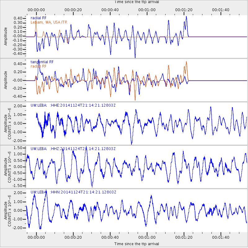
LEBA Lebam, WA, USA - Earthquake Result Viewer
*The percent match for this event was below the threshold and hence no stack was calculated.
| Earthquake location: |
Solomon Islands |
| Earthquake latitude/longitude: |
-6.0/155.0 |
| Earthquake time(UTC): |
2014/11/24 (328) 21:02:19 GMT |
| Earthquake Depth: |
170 km |
| Earthquake Magnitude: |
5.6 MWW, 5.6 MWB, 5.7 MWC |
| Earthquake Catalog/Contributor: |
NEIC PDE/NEIC COMCAT |
|
| Network: |
UW Pacific Northwest Regional Seismic Network |
| Station: |
LEBA Lebam, WA, USA |
| Lat/Lon: |
46.55 N/123.56 W |
| Elevation: |
73 m |
|
| Distance: |
88.4 deg |
| Az: |
43.065 deg |
| Baz: |
259.748 deg |
| Ray Param: |
$rayparam |
*The percent match for this event was below the threshold and hence was not used in the summary stack. |
|
| Radial Match: |
56.10631 % |
| Radial Bump: |
400 |
| Transverse Match: |
51.938686 % |
| Transverse Bump: |
400 |
| SOD ConfigId: |
820339 |
| Insert Time: |
2014-12-10 02:14:22.155 +0000 |
| GWidth: |
2.5 |
| Max Bumps: |
400 |
| Tol: |
0.001 |
|
Signal To Noise
| Channel | StoN | STA | LTA |
| UW:LEBA: :HHZ:20141124T21:14:21.12803Z | 0.63321126 | 4.1028431E-7 | 6.479422E-7 |
| UW:LEBA: :HHN:20141124T21:14:21.12803Z | 2.3964918 | 1.2484348E-6 | 5.2094265E-7 |
| UW:LEBA: :HHE:20141124T21:14:21.12803Z | 0.82989985 | 5.94146E-7 | 7.1592495E-7 |
| Arrivals |
| Ps | |
| PpPs | |
| PsPs/PpSs | |


