You are here: Home > Network List > PF - Volcanologic Network of Piton de Fournaise-OVPF Stations List
> Station FRE Station Sismologique des Fonds de la Riviere de l'Est > Earthquake Result Viewer
FRE Station Sismologique des Fonds de la Riviere de l'Est - Earthquake Result Viewer
| Earthquake location: |
Nepal |
| Earthquake latitude/longitude: |
27.8/86.1 |
| Earthquake time(UTC): |
2015/05/12 (132) 07:05:19 GMT |
| Earthquake Depth: |
15 km |
| Earthquake Magnitude: |
7.3 MWW |
| Earthquake Catalog/Contributor: |
NEIC PDE/NEIC COMCAT |
|
| Network: |
PF Volcanologic Network of Piton de Fournaise-OVPF |
| Station: |
FRE Station Sismologique des Fonds de la Riviere de l'Est |
| Lat/Lon: |
21.20 S/55.70 E |
| Elevation: |
1775 m |
|
| Distance: |
56.9 deg |
| Az: |
214.281 deg |
| Baz: |
32.313 deg |
| Ray Param: |
0.06381637 |
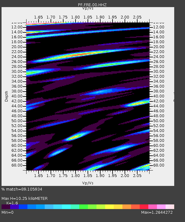
| Estimated Moho Depth: |
10.25 km |
| Estimated Crust Vp/Vs: |
1.60 |
| Assumed Crust Vp: |
4.73 km/s |
| Estimated Crust Vs: |
2.956 km/s |
| Estimated Crust Poisson's Ratio: |
0.18 |
|
| Radial Match: |
89.105934 % |
| Radial Bump: |
400 |
| Transverse Match: |
66.97464 % |
| Transverse Bump: |
400 |
| SOD ConfigId: |
7422571 |
| Insert Time: |
2019-04-18 20:12:37.058 +0000 |
| GWidth: |
2.5 |
| Max Bumps: |
400 |
| Tol: |
0.001 |
|
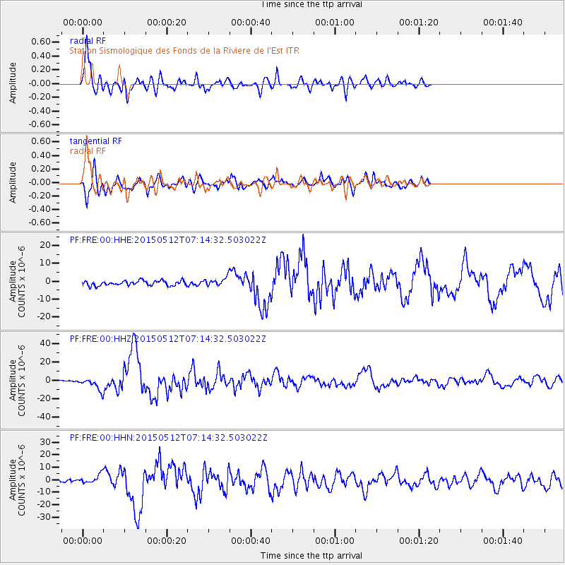
Signal To Noise
| Channel | StoN | STA | LTA |
| PF:FRE:00:HHZ:20150512T07:14:32.503022Z | 4.557259 | 6.603166E-6 | 1.4489337E-6 |
| PF:FRE:00:HHN:20150512T07:14:32.503022Z | 3.0204382 | 3.7547004E-6 | 1.2430979E-6 |
| PF:FRE:00:HHE:20150512T07:14:32.503022Z | 1.5013324 | 2.0260097E-6 | 1.3494745E-6 |
| Arrivals |
| Ps | 1.3 SECOND |
| PpPs | 5.5 SECOND |
| PsPs/PpSs | 6.8 SECOND |


